IMAGES TAKEN NEAR TO
Bristol Road, AXBRIDGE, BS26 2TT
Introduction
This page details the photographs taken nearby to Bristol Road, BS26 2TT by members of the Geograph project.
The Geograph project started in 2005 with the aim of publishing, organising and preserving representative images for every square kilometre of Great Britain, Ireland and the Isle of Man.

There are currently over 7.5m images from over14,400 individuals and you can help contribute to the project by visiting https://www.geograph.org.uk
Image Map (Loading...)


Getting Data...Please wait
Leaflet Map data © OpenStreetMap
Images are licensed for reuse under creativecommons.org/licenses/by-sa/2.0
Notes
- Clicking on the map will re-center to the selected point.
- The higher the marker number, the further away the image location is from the centre of the postcode.
Image Listing (13 Images Found)
Images are licensed for reuse under creativecommons.org/licenses/by-sa/2.0
Image
Details
Distance
3
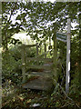
Getting off the Bristol Road
Rooks Bridge only has one public footpath in the heart of the village. This takes travellers across the field after hopping over the drain.
Image: © Neil Owen
Taken: 30 Aug 2018
0.19 miles
5
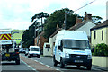
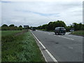
Rooks Bridge
Busy traffic on the A38 Bristol Road at Rooks Bridge.
Image: © Robert Ashby
Taken: 16 Aug 2014
0.20 miles
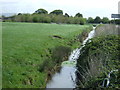
6
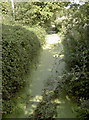
Two shades of green
The rhyne running parallel with the A38 teems with pondweed.
Image: © Neil Owen
Taken: 30 Aug 2018
0.21 miles
7
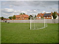
Just the one goal
A small patch of grass beside the new housing off Pill Road provides half a game.
Image: © Neil Owen
Taken: 30 Aug 2018
0.21 miles
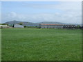
9
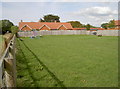
A little room for recreation
At the other end of the grassed area are some traditional playground installations. Plenty of room for a good runaround, too.
Image: © Neil Owen
Taken: 30 Aug 2018
0.22 miles
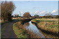
10
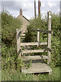
A shorter route to Pill Road
The footpath crosses a drainage stream.
Image: © Neil Owen
Taken: 30 Aug 2018
0.22 miles