IMAGES TAKEN NEAR TO
Josephs Pound, AXBRIDGE, BS26 2TP
Introduction
This page details the photographs taken nearby to Josephs Pound, BS26 2TP by members of the Geograph project.
The Geograph project started in 2005 with the aim of publishing, organising and preserving representative images for every square kilometre of Great Britain, Ireland and the Isle of Man.

There are currently over 7.5m images from over14,400 individuals and you can help contribute to the project by visiting https://www.geograph.org.uk
Image Map (Loading...)


Getting Data...Please wait
Leaflet Map data © OpenStreetMap
Images are licensed for reuse under creativecommons.org/licenses/by-sa/2.0
Notes
- Clicking on the map will re-center to the selected point.
- The higher the marker number, the further away the image location is from the centre of the postcode.
Image Listing (24 Images Found)
Images are licensed for reuse under creativecommons.org/licenses/by-sa/2.0
Image
Details
Distance
1
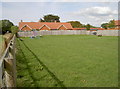
A little room for recreation
At the other end of the grassed area are some traditional playground installations. Plenty of room for a good runaround, too.
Image: © Neil Owen
Taken: 30 Aug 2018
0.02 miles
2
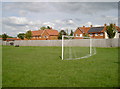
Just the one goal
A small patch of grass beside the new housing off Pill Road provides half a game.
Image: © Neil Owen
Taken: 30 Aug 2018
0.04 miles
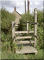
3
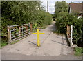
From Pill Road to Gills Lane
A useful bridge across the many drainage ditches hereabouts, although cars are usually prevented.
Image: © Neil Owen
Taken: 30 Aug 2018
0.05 miles
4
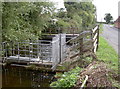
Sluice in Pill Road
The area around Rooks Bridge is pretty low-lying, as befits much of Somerset. Water management is a common feature.
Image: © Neil Owen
Taken: 30 Aug 2018
0.06 miles
5
A shorter route to Pill Road
The footpath crosses a drainage stream.
Image: © Neil Owen
Taken: 30 Aug 2018
0.06 miles
7
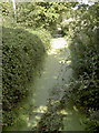
Two shades of green
The rhyne running parallel with the A38 teems with pondweed.
Image: © Neil Owen
Taken: 30 Aug 2018
0.08 miles
8
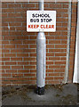
A little hop onto the bus
A rather unpretentious sign for the little ones to go to school; in Gills Lane.
Image: © Neil Owen
Taken: 30 Aug 2018
0.09 miles
9
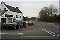
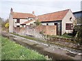
Rooks Bridge
On the A38 Bristol to Taunton
Image: © Adrian and Janet Quantock
Taken: 18 Dec 2005
0.10 miles
10
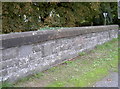
The bridge at Rooks Bridge
Somerset County Council engaged on a campaign to mark the various bridges with nicely carved legends on the parapets. This proudly proclaims the bridge was widened in 1929. However, a closer look at the stonework reveals a noticeable shifting of the central section - probably as a result of a vehicle strike.
Image: © Neil Owen
Taken: 30 Aug 2018
0.10 miles