IMAGES TAKEN NEAR TO
Tarnock, AXBRIDGE, BS26 2SL
Introduction
This page details the photographs taken nearby to BS26 2SL by members of the Geograph project.
The Geograph project started in 2005 with the aim of publishing, organising and preserving representative images for every square kilometre of Great Britain, Ireland and the Isle of Man.

There are currently over 7.5m images from over14,400 individuals and you can help contribute to the project by visiting https://www.geograph.org.uk
Image Map (Loading...)


Getting Data...Please wait
Leaflet Map data © OpenStreetMap
Images are licensed for reuse under creativecommons.org/licenses/by-sa/2.0
Notes
- Clicking on the map will re-center to the selected point.
- The higher the marker number, the further away the image location is from the centre of the postcode.
Image Listing (8 Images Found)
Images are licensed for reuse under creativecommons.org/licenses/by-sa/2.0
Image
Details
Distance

5
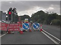
Rooks Bridge : Bristol Road A38
Waiting at the roadworks on Bristol Road.
Image: © Lewis Clarke
Taken: 29 Jun 2020
0.23 miles
6
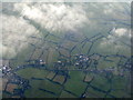
The A38 at Tarnock
Seen looking south from the downwind leg to Bristol Airport. Low lying farmland at the edge of the Somerset Levels.
Image: © M J Richardson
Taken: 30 Dec 2014
0.24 miles