IMAGES TAKEN NEAR TO
Tarnock, AXBRIDGE, BS26 2SB
Introduction
This page details the photographs taken nearby to BS26 2SB by members of the Geograph project.
The Geograph project started in 2005 with the aim of publishing, organising and preserving representative images for every square kilometre of Great Britain, Ireland and the Isle of Man.

There are currently over 7.5m images from over14,400 individuals and you can help contribute to the project by visiting https://www.geograph.org.uk
Image Map (Loading...)


Getting Data...Please wait
Leaflet Map data © OpenStreetMap
Images are licensed for reuse under creativecommons.org/licenses/by-sa/2.0
Notes
- Clicking on the map will re-center to the selected point.
- The higher the marker number, the further away the image location is from the centre of the postcode.
Image Listing (6 Images Found)
Images are licensed for reuse under creativecommons.org/licenses/by-sa/2.0
Image
Details
Distance
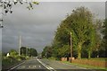
2
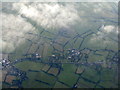
The A38 at Tarnock
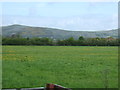
Seen looking south from the downwind leg to Bristol Airport. Low lying farmland at the edge of the Somerset Levels.
Image: © M J Richardson
Taken: 30 Dec 2014
0.07 miles
4
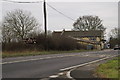
A38 at Biddisham Bridge
The main road curves east of Tarnock. Behind the tractor is a lay-by, representing an even greater curve before the road was slightly straightened.
Image: © Derek Harper
Taken: 17 Aug 2013
0.16 miles
5
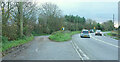
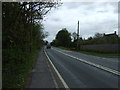
A38 at Biddisham Bridge
The busy A38 makes a right turn, with strong evidence of a sharper bend now used as a lay-by. The bridge is over a winding rhyne, which goes beneath the grass island.
Image: © Derek Harper
Taken: 20 Nov 2023
0.21 miles