IMAGES TAKEN NEAR TO
Coombes Way, AXBRIDGE, BS26 2RL
Introduction
This page details the photographs taken nearby to Coombes Way, BS26 2RL by members of the Geograph project.
The Geograph project started in 2005 with the aim of publishing, organising and preserving representative images for every square kilometre of Great Britain, Ireland and the Isle of Man.

There are currently over 7.5m images from over14,400 individuals and you can help contribute to the project by visiting https://www.geograph.org.uk
Image Map
Images are licensed for reuse under creativecommons.org/licenses/by-sa/2.0
Notes
- Clicking on the map will re-center to the selected point.
- The higher the marker number, the further away the image location is from the centre of the postcode.
Image Listing (20 Images Found)
Images are licensed for reuse under creativecommons.org/licenses/by-sa/2.0
Image
Details
Distance
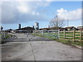
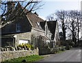
4
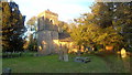
Outbuildings of Green Farm
You can just see the top of Brent Knoll in the background.
Image: © Adrian and Janet Quantock
Taken: 18 Dec 2005
0.12 miles
7
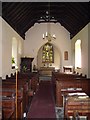
Interior of St John the Baptist Church, Biddisham
Image: © John Lord
Taken: 26 Apr 2011
0.15 miles
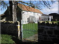
8
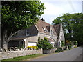
St John The Baptist Church, Biddisham
Located in Biddisham Lane off the A38 at Biddisham. Next to the church is the old school house which is now a private dwelling.
Image: © Howard
Taken: 1 Nov 2011
0.15 miles
10
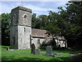
Biddisham, Somerset
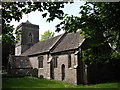
Church of St John the Baptist. Note the tower started to lean and so the top stage has had its verticality corrected - look carefully!
Image: © ChurchCrawler
Taken: 20 Jul 2004
0.15 miles