IMAGES TAKEN NEAR TO
Scotland Lane, AXBRIDGE, BS26 2PB
Introduction
This page details the photographs taken nearby to Scotland Lane, BS26 2PB by members of the Geograph project.
The Geograph project started in 2005 with the aim of publishing, organising and preserving representative images for every square kilometre of Great Britain, Ireland and the Isle of Man.

There are currently over 7.5m images from over14,400 individuals and you can help contribute to the project by visiting https://www.geograph.org.uk
Image Map
Images are licensed for reuse under creativecommons.org/licenses/by-sa/2.0
Notes
- Clicking on the map will re-center to the selected point.
- The higher the marker number, the further away the image location is from the centre of the postcode.
Image Listing (20 Images Found)
Images are licensed for reuse under creativecommons.org/licenses/by-sa/2.0
Image
Details
Distance
1
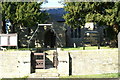
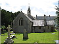
United Benefice of Mark and Allerton Church
Image: © Adrian and Janet Quantock
Taken: 28 Jan 2006
0.03 miles
2
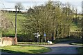
Junction of Front Street and New Road, Chapel Allerton
Image: © David Martin
Taken: 19 Feb 2023
0.06 miles
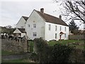
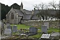
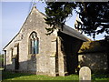
5
Allerton church
As far as I have been able to establish, this church has no name (i.e. it is not dedicated to any saint).
Image: © David Purchase
Taken: 8 Aug 2011
0.10 miles
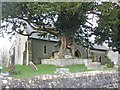
6
Allerton Church, Chapel Allerton
A church has stood at Chapel Allerton at least since 1176
Image: © PAUL FARMER
Taken: 18 Feb 2017
0.10 miles
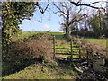
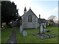
8
The Parish Church and churchyard, Chapel Allerton
Image: © David Martin
Taken: 18 Feb 2023
0.11 miles
10
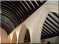
Arches and roof timbers, Chapel Allerton church
Image: © John Lord
Taken: 26 Apr 2011
0.12 miles