IMAGES TAKEN NEAR TO
Farthing Combe, AXBRIDGE, BS26 2DR
Introduction
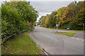
This page details the photographs taken nearby to Farthing Combe, BS26 2DR by members of the Geograph project.
The Geograph project started in 2005 with the aim of publishing, organising and preserving representative images for every square kilometre of Great Britain, Ireland and the Isle of Man.

There are currently over 7.5m images from over14,400 individuals and you can help contribute to the project by visiting https://www.geograph.org.uk
Image Map
Images are licensed for reuse under creativecommons.org/licenses/by-sa/2.0
Notes
- Clicking on the map will re-center to the selected point.
- The higher the marker number, the further away the image location is from the centre of the postcode.
Image Listing (24 Images Found)
Images are licensed for reuse under creativecommons.org/licenses/by-sa/2.0
Image
Details
Distance
1
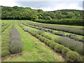
Lavender field, Axbridge
Lavender & Co's field on the slopes of Fry's Hill in the Mendips would have looked more impressive before harvesting, but there are still plenty of bushes in bloom. http://www.lavenderandco.co.uk/index.html .
Image: © Derek Harper
Taken: 12 Aug 2011
0.07 miles
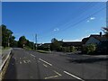
2
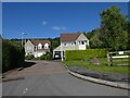
Barnabas Close, Axbridge
A short road with modern houses
Image: © David Smith
Taken: 1 Oct 2021
0.11 miles
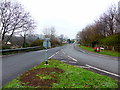
3
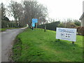
The road to Cheddar reservoir
This lane goes to the reservoir, and the activities that use it. The reservoir was constructed in 1933 to assist the supply to Bristol and the surrounds.
Image: © Neil Owen
Taken: 14 Dec 2020
0.11 miles
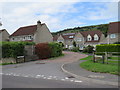
4
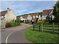
Barnabas Close, Axbridge
A cul-de-sac of modern houses, off Cheddar Road at the east end of the town.
Image: © Derek Harper
Taken: 15 Aug 2011
0.11 miles
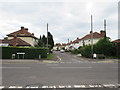
6
Barnabas Close, Axbridge
Barnabas Close is a modern housing development in the village of Axbridge in Somerset.
Image: © Malc McDonald
Taken: 23 Aug 2020
0.13 miles
8
Parkfield Road, Axbridge
Parkfield Road is a residential road in the village of Axbridge in Somerset.
Image: © Malc McDonald
Taken: 23 Aug 2020
0.15 miles
9
Strawberry Line
At this point the path starts an on-road section through Axbridge.
Image: © Guy Wareham
Taken: 28 Oct 2016
0.15 miles
10
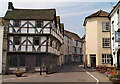
Axbridge, Somerset
The main street in Axbridge, Somerset, looking west from the square. The timbered building is called King John's Hunting Lodge, although it was built much later than the time when Anglo-Saxon and Norman kings used Axbridge as a base for hunting.
Image: © Martin Clark
Taken: Unknown
0.15 miles