IMAGES TAKEN NEAR TO
Old Church Road, AXBRIDGE, BS26 2BG
Introduction
This page details the photographs taken nearby to Old Church Road, BS26 2BG by members of the Geograph project.
The Geograph project started in 2005 with the aim of publishing, organising and preserving representative images for every square kilometre of Great Britain, Ireland and the Isle of Man.

There are currently over 7.5m images from over14,400 individuals and you can help contribute to the project by visiting https://www.geograph.org.uk
Image Map (Loading...)


Getting Data...Please wait
Leaflet Map data © OpenStreetMap
Images are licensed for reuse under creativecommons.org/licenses/by-sa/2.0
Notes
- Clicking on the map will re-center to the selected point.
- The higher the marker number, the further away the image location is from the centre of the postcode.
Image Listing (302 Images Found)
Images are licensed for reuse under creativecommons.org/licenses/by-sa/2.0
Image
Details
Distance
1
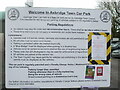
Take your time!
The terms and conditions of the car park in Axbridge have been revised! In response to the Covid-19 downturn in trade, it seems that some slack is being cut and the time restrictions here are suspended.
Image: © Neil Owen
Taken: 14 Dec 2020
0.02 miles
2
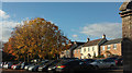
Car park, Axbridge
On the right are modern houses at Reads Garden; on the immediate right is the corner of a listed "barn" https://historicengland.org.uk/listing/the-list/list-entry/1173035 .
Image: © Derek Harper
Taken: 1 Nov 2018
0.02 miles
3
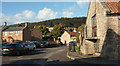
Corner of Axbridge
Looking right from where Image] was taken, with a better view of the listed building https://historicengland.org.uk/listing/the-list/list-entry/1173035 on the immediate right.
Image: © Derek Harper
Taken: 1 Nov 2018
0.04 miles
4
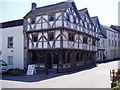
King John's Hunting Lodge
Museum on the high street in Axbridge. Why it is called "King John's" is unknown, especially since it was built about three centuries after his death. John reigned from 1199 to 1216, but the Axbridge house was built in the 15th century. The king owned the demesnes of Cheddar and Axbridge, which constituted part of the royal forest of Mendip, and he was an enthusiastic hunter, often visiting the Mendip Hills; it was he who granted Axbridge its first royal charter.
Image: © Eirian Evans
Taken: 13 Jun 2005
0.04 miles
5
West Street, Axbridge, looking across the village square
Image: © David Gearing
Taken: 10 Apr 2015
0.04 miles
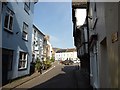
7
Houlgate Way, Axbridge
Axbridge has been twinned with the Normandy town of Houlgate since 1970. The modern road serves as a bus route to the town centre avoiding the very narrow West Street,
Image: © Derek Harper
Taken: 1 Nov 2018
0.06 miles
8
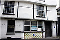
9 High Street, Axbridge
Grade II* Listed late 15th or early 16th century timber framed shop and house with late 18th century fenestration. It may always have been a butcher's shop but the glazed tiles were added in the 19th century. The property was renovated to a three-storey period town house in 2006 by Mendip Homes Image The window reads "Where in all England is there another Butcher's Shop with a magnificent entrance like that? Sir John Betjeman 1963".
Image: © Jo and Steve Turner
Taken: 21 Mar 2005
0.07 miles
9
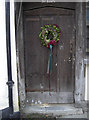
Need fresh for Santa and the reindeer
St Jude's is a house/shop dating in part back to the late fifteenth century, with the ribbed and studded wooden door probably sixteenth century. The empty milk bottles are an added touch.
Image: © Neil Owen
Taken: 23 Dec 2015
0.07 miles
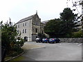
10
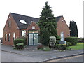
Axbridge surgery
A modern facility on the edge of the village, soon to be fully surrounded by new housing.
Image: © Neil Owen
Taken: 8 Dec 2022
0.07 miles