IMAGES TAKEN NEAR TO
Station Road, WINSCOMBE, BS25 5RF
Introduction
This page details the photographs taken nearby to Station Road, BS25 5RF by members of the Geograph project.
The Geograph project started in 2005 with the aim of publishing, organising and preserving representative images for every square kilometre of Great Britain, Ireland and the Isle of Man.

There are currently over 7.5m images from over14,400 individuals and you can help contribute to the project by visiting https://www.geograph.org.uk
Image Map
Images are licensed for reuse under creativecommons.org/licenses/by-sa/2.0
Notes
- Clicking on the map will re-center to the selected point.
- The higher the marker number, the further away the image location is from the centre of the postcode.
Image Listing (37 Images Found)
Images are licensed for reuse under creativecommons.org/licenses/by-sa/2.0
Image
Details
Distance
1
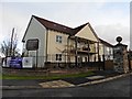
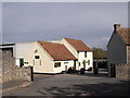
Entrance, Sandford Station retirement village
Image: © Roger Cornfoot
Taken: 17 Jan 2018
0.04 miles
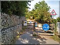
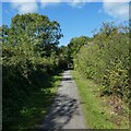
3
A Frame Barrier on Strawberry Line NCN26 in Sandford
An A frame barrier just past the entrance to the stretch of the Strawberry line from the A368 Station Road crossing in Sandford to Nye Road in Sandford.
Gap between the barriers is 70cm.
The path here is a packed grit which is reasonably smooth, although there will be puddles and muddy patches in wet weather.
The path is a fairly steep climb from the barrier chicane by the road to here.
Note that there is a path diversion a short way past here at the date of the photo (08/09/2021) which takes a path around a field and is very uneven in places and will be muddy and slippery in wet weather.
Image: © Kevin Pearson
Taken: 8 Sep 2021
0.06 miles
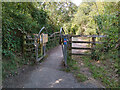
4
Barrier Chicane on Strawberry Line NCN26 in Sandford
A wooden barrier chicane at the entrance to the stretch of the Strawberry line from the A368 Station Road crossing in Sandford to Nye Road in Sandford.
Gap between the barriers over 1m, and the gap between the barriers and the wall / fence is also over 1m.
The path here is a packed grit which is reasonably smooth, although there will be puddles and muddy patches in wet weather.
The path is a fairly steep climb from here to the A frame barrier just around the bend.
Note that there is a path diversion a short way past here at the date of the photo (08/09/2021) which takes a path around a field and is very uneven in places and will be muddy and slippery in wet weather.
Image: © Kevin Pearson
Taken: 8 Sep 2021
0.07 miles
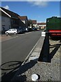
8
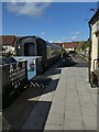
Platform and former railway rolling stock, Sandford station
The open wagon on the left can be used as a seating area for refreshments
Image: © David Smith
Taken: 1 Oct 2021
0.09 miles
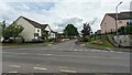
9
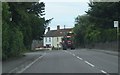
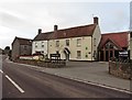
Station Road in Sandford
The short, dark signboard in the distance indicates the location of the head office of a well known local cider producer.
Image: © Ruth Riddle
Taken: 17 Jul 2012
0.09 miles
10
Housing estate by former Sandford railway station
The former station is now a museum, and is integrated into the housing estate
Image: © David Smith
Taken: 1 Oct 2021
0.09 miles