IMAGES TAKEN NEAR TO
Southleaze, WINSCOMBE, BS25 1ND
Introduction
This page details the photographs taken nearby to Southleaze, BS25 1ND by members of the Geograph project.
The Geograph project started in 2005 with the aim of publishing, organising and preserving representative images for every square kilometre of Great Britain, Ireland and the Isle of Man.

There are currently over 7.5m images from over14,400 individuals and you can help contribute to the project by visiting https://www.geograph.org.uk
Image Map (20 Images)


Getting Data...Please wait
Leaflet Map data © OpenStreetMap
Images are licensed for reuse under creativecommons.org/licenses/by-sa/2.0
Notes
- Clicking on the map will re-center to the selected point.
- The higher the marker number, the further away the image location is from the centre of the postcode.
Image Listing (20 Images Found)
Images are licensed for reuse under creativecommons.org/licenses/by-sa/2.0
Image
Details
Distance
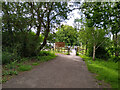
1
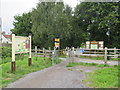
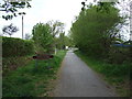
Strawberry Line path at Winscombe
The Strawberry Line path at Winscombe in Somerset. The path forms part of National Cycle Network route 26.
Image: © Malc McDonald
Taken: 23 Aug 2020
0.05 miles
3

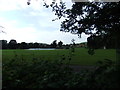
Family outing
These cygnets look like teenagers ready to leave home.
Image: © Anthony O'Neil
Taken: 27 Sep 2009
0.11 miles
5
Strawberry Line path near Winscombe
A gate on the Strawberry Line path in Somerset. The path is on the route of National Cycle Network route 26.
Image: © Malc McDonald
Taken: 23 Aug 2020
0.14 miles
6
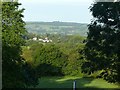
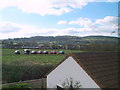
The caterpillar has morphed
View from Sidcot Hotel towards Bleadon Hill.
One of the landmarks of my childhood in the 1950s is no longer to be seen. Back then, there was no woodland on the face of the hill. The stand of trees – the three bumps rising above the woodland, located at Image – stood clear of the ridge, looking like a giant caterpillar walking along the ridge, and 'Caterpillar' was the local name for the hill. (An alternative, related to the same group of trees, was 'Ship Hill'.)
Image: © Alan Murray-Rust
Taken: 26 Sep 2019
0.15 miles
7
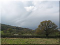
The Strawberry Line (railway trail)
Heading north into Winscombe.
Image: © JThomas
Taken: 10 May 2013
0.16 miles
8
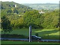
View from the Sidcot Hotel
The tower of Winscombe church rises from the trees on the side of Wavering Down.
Image: © Alan Murray-Rust
Taken: 26 Sep 2019
0.16 miles
9
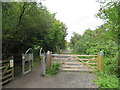
A Frame Barriers on Strawberry Line NCN26
Two sets of A frame barriers on the Strawberry Line / NCN26, photographed from the south side of the obstacle.
Location of the barriers is by the access road to Winscombe Playing Field.
Width of the gap through the barriers is 70cm.
Image: © Kevin Pearson
Taken: 22 Jun 2021
0.17 miles