IMAGES TAKEN NEAR TO
Sandford Road, WINSCOMBE, BS25 1JA
Introduction
This page details the photographs taken nearby to Sandford Road, BS25 1JA by members of the Geograph project.
The Geograph project started in 2005 with the aim of publishing, organising and preserving representative images for every square kilometre of Great Britain, Ireland and the Isle of Man.

There are currently over 7.5m images from over14,400 individuals and you can help contribute to the project by visiting https://www.geograph.org.uk
Image Map
Images are licensed for reuse under creativecommons.org/licenses/by-sa/2.0
Notes
- Clicking on the map will re-center to the selected point.
- The higher the marker number, the further away the image location is from the centre of the postcode.
Image Listing (42 Images Found)
Images are licensed for reuse under creativecommons.org/licenses/by-sa/2.0
Image
Details
Distance
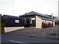
1

Winscombe Fire Station
Winscombe Fire Station, Sandford Road, Winscombe is station number 24 of Avon Fire & Rescue Service
Image: © Kevin Hale
Taken: 8 May 2006
0.01 miles
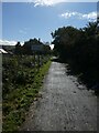
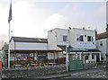
2
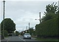
Sandford Road in Winscombe
Looking northwards.
Image: © Ruth Riddle
Taken: 17 Jul 2012
0.01 miles
3
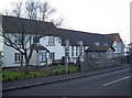
Council chambers and community centre
The Parish Council sits here, whilst the Community Association is next door. The buildings were originally Winscombe and Woodborough Primary School, opening in the mid-nineteenth century. Following the growth of the population and subsequent squeeze on spaces, more school rooms were built elsewhere. Eventually, local moves to the authorities to turn the school over to parish and community use were granted in 1979. It now is a welcoming facility for all.
Image: © Neil Owen
Taken: 25 Jan 2017
0.09 miles
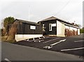
4
Winscombe Bowling Club
The club began playing in 1921, using a homeowner's lawn. The following year the club sought to raise funds to establish a proper venue. Shares in the venture at £5 each were soon snapped up and the club laid out a green here. Today, the club continues to compete and even has floodlights for night matches!
Image: © Neil Owen
Taken: 25 Jan 2017
0.09 miles
6
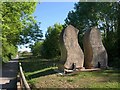
Millennium Green Sculpture, Winscombe
Another view of Image from the opposite direction. This is the work of Dick Boulton, carved in Doulting limestone, a stone carried on this railway.
"The sculpture symbolises a pair of railway lines snaking away into the distance. Some people say that the ‘SS’ stands for ‘Strawberry Special’, the name given to the regular passenger train service along the Cheddar Valley Railway, the railway which passed through Winscombe" http://www.wsmg.org.uk/
Image: © Derek Harper
Taken: 24 May 2010
0.10 miles
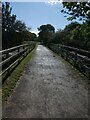
7
Strawberry Line north of site of Winscombe station
Image: © David Smith
Taken: 1 Oct 2021
0.10 miles
8
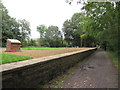
Winscombe former railway station
The Strawberry Line path passing through the former railway station at Winscombe in Somerset. The station closed in 1963, but the platform is restored.
The path forms part of National Cycle Network route 26.
Image: © Malc McDonald
Taken: 23 Aug 2020
0.11 miles
10
Winscombe Club
The Winscombe Club on Sandford Road is a recent conversion - the R.B.L. no longer preside here, despite the signage.
Image: © Neil Owen
Taken: 25 Jan 2017
0.13 miles