IMAGES TAKEN NEAR TO
The Lynch, WINSCOMBE, BS25 1AN
Introduction
This page details the photographs taken nearby to The Lynch, BS25 1AN by members of the Geograph project.
The Geograph project started in 2005 with the aim of publishing, organising and preserving representative images for every square kilometre of Great Britain, Ireland and the Isle of Man.

There are currently over 7.5m images from over14,400 individuals and you can help contribute to the project by visiting https://www.geograph.org.uk
Image Map (Loading...)


Getting Data...Please wait
Leaflet Map data © OpenStreetMap
Images are licensed for reuse under creativecommons.org/licenses/by-sa/2.0
Notes
- Clicking on the map will re-center to the selected point.
- The higher the marker number, the further away the image location is from the centre of the postcode.
Image Listing (60 Images Found)
Images are licensed for reuse under creativecommons.org/licenses/by-sa/2.0
Image
Details
Distance
1
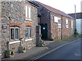
Scouts Hall
This building was once the Woodburrow British School from 1863-1921; thereafter it became the meeting rooms for the Temperance Society and the Men's Institute. From 1968, it has been the home of the 1st Winscombe Scout Group Headquarters.
Image: © Neil Owen
Taken: 25 Jan 2017
0.01 miles
2
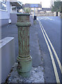
Low level lighting
This shortened utility appears to have been an old light standard.
Image: © Neil Owen
Taken: 25 Jan 2017
0.03 miles
4
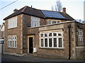
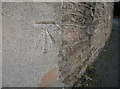
The old bank
There has been a bank branch here since the early twentieth century, but seems to have changed now. You might just be able to make out the ghostly National Westminster lettering. A benchmark is on the near corner - see Image
Image: © Neil Owen
Taken: 25 Jan 2017
0.06 miles
5
Bank benchmark
A cutmark, as listed in the Benchmark Database: http://www.bench-marks.org.uk/bm81689 , on the corner of the old bank in Winscombe. See Image] for a wider view.
Image: © Neil Owen
Taken: 25 Jan 2017
0.06 miles
6
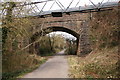
Strawberry Line
The bridge carrying the pipe over the track still has what appears to be a smoke deflector.
Image: © Guy Wareham
Taken: 6 Mar 2009
0.07 miles
7
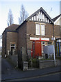
Winscombe post office
Up until the mid-twentieth century, the village Post Office was situated around the corner in Sidcot Lane.
Image: © Neil Owen
Taken: 25 Jan 2017
0.08 miles
8
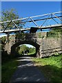
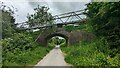
The Lynch bridge over Strawberry Line, Winscombe
Image: © David Smith
Taken: 1 Oct 2021
0.08 miles
9
Bridge and Pipe over the Strawberry Line
Image: © Sandy Gerrard
Taken: 3 Jun 2024
0.08 miles
10
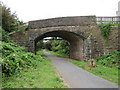
Bridge over the Strawberry Line path, Winscombe
The Strawberry Line path at Winscombe in Somerset. The path forms part of National Cycle Network route 26. The bridge carrying a road across the path is a relic from when the path was a railway line.
Image: © Malc McDonald
Taken: 23 Aug 2020
0.08 miles