IMAGES TAKEN NEAR TO
Moorcroft Road, WESTON-SUPER-MARE, BS24 9RW
Introduction
This page details the photographs taken nearby to Moorcroft Road, BS24 9RW by members of the Geograph project.
The Geograph project started in 2005 with the aim of publishing, organising and preserving representative images for every square kilometre of Great Britain, Ireland and the Isle of Man.

There are currently over 7.5m images from over14,400 individuals and you can help contribute to the project by visiting https://www.geograph.org.uk
Image Map (Loading...)


Getting Data...Please wait
Leaflet Map data © OpenStreetMap
Images are licensed for reuse under creativecommons.org/licenses/by-sa/2.0
Notes
- Clicking on the map will re-center to the selected point.
- The higher the marker number, the further away the image location is from the centre of the postcode.
Image Listing (26 Images Found)
Images are licensed for reuse under creativecommons.org/licenses/by-sa/2.0
Image
Details
Distance
1
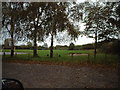
Football Ground in Hutton Village
Image: © Adrian and Janet Quantock
Taken: 5 Nov 2005
0.20 miles
2
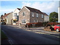
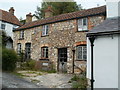
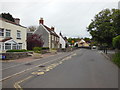
Hutton Chip Shop & Rose Glen Cottage
Located on the main road through Hutton Village
Image: © Adrian and Janet Quantock
Taken: 22 Oct 2005
0.21 miles
3
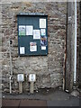
Parish notices
Hutton has this organ by the side of the post office. An assortment of services and offers.
Image: © Neil Owen
Taken: 3 Jul 2021
0.22 miles
4
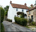
Jasmine Cottage, Hutton
Located on Eastfield Road, near the corner of Hutton Hill. Its neighbour on the right is Monks Revel. http://www.geograph.org.uk/photo/2535520
Image: © Jaggery
Taken: 27 Jul 2011
0.22 miles
5
Monks Revel, Hutton
Interestingly named (and coloured) house on Eastfield Road, near the Hutton Hill junction.
One reference source suggests the building may have been the village poor house, built in 1806, but gives no explanation of its current name.
The white building on the left is Jasmine Cottage. http://www.geograph.org.uk/photo/2535527
Image: © Jaggery
Taken: 27 Jul 2011
0.22 miles
6
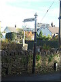
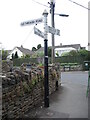
Direction Sign - Signpost on Main Road in Hutton
Located on the northwest side of the T junction of Main Road and Moor Lane. Hutton parish. 3 arms and pyramid finial. For an earlier photo see https://www.geograph.org.uk/photo/6056557.
Milestone Society National ID: SO_ST3558A
Image: © P Collins
Taken: 4 Nov 2023
0.23 miles
7
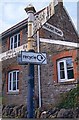
Direction Sign - Signpost on Main Road in Hutton
Pyramid finial - 3 arms; Somerset SCC pyramid by the UC road, in parish of Hutton (North Somerset District), on the northwest side of the T junction of Main Road and Moor Lane. For a more recent photo, see https://www.geograph.org.uk/photo/7650810.
surveyed
Milestone Society National ID: SO_ST3558A
Image: © J Dowding
Taken: 1 Mar 2013
0.23 miles
8
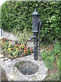
Hutton's old water pump
A pump stands on the site of the last communal water supply in Hutton before mains supplies came along.
Image: © Neil Owen
Taken: 3 Jul 2021
0.23 miles
10
Moor Lane is a no through road
Moor Lane reaches down to the playing fields but stops at the Cross Rhyne. A typical Somerset style signpost.
Image: © Neil Owen
Taken: 3 Jul 2021
0.23 miles