IMAGES TAKEN NEAR TO
Faversham Drive, WESTON-SUPER-MARE, BS24 9NZ
Introduction
This page details the photographs taken nearby to Faversham Drive, BS24 9NZ by members of the Geograph project.
The Geograph project started in 2005 with the aim of publishing, organising and preserving representative images for every square kilometre of Great Britain, Ireland and the Isle of Man.

There are currently over 7.5m images from over14,400 individuals and you can help contribute to the project by visiting https://www.geograph.org.uk
Image Map
Images are licensed for reuse under creativecommons.org/licenses/by-sa/2.0
Notes
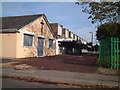
- Clicking on the map will re-center to the selected point.
- The higher the marker number, the further away the image location is from the centre of the postcode.
Image Listing (15 Images Found)
Images are licensed for reuse under creativecommons.org/licenses/by-sa/2.0
Image
Details
Distance
1
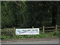
Sign for the May Day fayre
Located on Totterdown Lane, and not in an obviously prominent position.
Image: © Neil Owen
Taken: 25 Apr 2023
0.08 miles
2
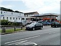
AW Leisure, Weston-super-Mare
Located on the south side of Broadway. A sign on the premises describes the business as "New and nearly new vehicle sales and leasing".
Image: © Jaggery
Taken: 27 Jul 2011
0.12 miles
3
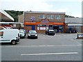
Atlantic Broadway, Weston-super-Mare
Located on the south side of Broadway between AW Leisure http://www.geograph.org.uk/photo/2562594 and a Tesco Express store.
Originally a fish and chip shop, now also a burger bar, as shown by a sign on the building.
Image: © Jaggery
Taken: 27 Jul 2011
0.12 miles
4
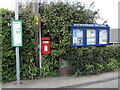
Important notices on Totterdown Lane
Some local info at your disposal.
Image: © Neil Owen
Taken: 25 Apr 2023
0.13 miles
5
Beechmount Close and Beechmount Drive, Weston-super-Mare
In the background are Beechmount Drive houses, with Beechmount Close houses at centre right. Viewed across Broadway.
Image: © Jaggery
Taken: 27 Jul 2011
0.14 miles
6
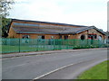
Oldmixon Family Centre, Weston-super-Mare
Located on Monkton Avenue, next door to Oldmixon Primary School. http://www.geograph.org.uk/photo/2562255
Image: © Jaggery
Taken: 27 Jul 2011
0.17 miles
7
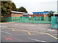
Oldmixon Primary School, Weston-super-Mare
Viewed across Monkton Avenue. There are about 240 pupils enrolled (ages 3 to 11).
Image: © Jaggery
Taken: 27 Jul 2011
0.17 miles
8
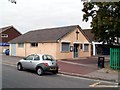
Barnabas Open Doors Centre, Oldmixon, Weston-super-Mare
Located at the western end of Aller Parade, the centre is run by St Barnabas Church, Westbury Crescent, Oldmixon.
Image: © Jaggery
Taken: 27 Jul 2011
0.17 miles
9
Aller Parade
Local shops on Oldmixon Estate
Image: © Adrian and Janet Quantock
Taken: 22 Oct 2005
0.18 miles
10
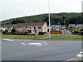
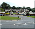
Mini-roundabout and bungalows, Broadway, Weston-super-Mare
Walnut Close bungalows face Broadway, a mini-roundabout, Winterstoke Road and the Walnut Tree pub. http://www.geograph.org.uk/photo/2559247 Turn left for Hutton, Locking and Banwell. Turn right for the hospital, Uphill, Bleadon and the beach. Also for Bridgwater and Taunton.
A temporary yellow sign points towards a sand sculpture festival.
Image: © Jaggery
Taken: 27 Jul 2011
0.18 miles