IMAGES TAKEN NEAR TO
Dunster Crescent, WESTON-SUPER-MARE, BS24 9DT
Introduction
This page details the photographs taken nearby to Dunster Crescent, BS24 9DT by members of the Geograph project.
The Geograph project started in 2005 with the aim of publishing, organising and preserving representative images for every square kilometre of Great Britain, Ireland and the Isle of Man.

There are currently over 7.5m images from over14,400 individuals and you can help contribute to the project by visiting https://www.geograph.org.uk
Image Map (Loading...)


Getting Data...Please wait
Leaflet Map data © OpenStreetMap
Images are licensed for reuse under creativecommons.org/licenses/by-sa/2.0
Notes
- Clicking on the map will re-center to the selected point.
- The higher the marker number, the further away the image location is from the centre of the postcode.
Image Listing (19 Images Found)
Images are licensed for reuse under creativecommons.org/licenses/by-sa/2.0
Image
Details
Distance
1
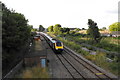
An evening local train pulls out to mainline
This southbound train is pulling out onto the main line after stopping at Weston Super Mare. The picture taken from the Broadway road bridge.
Image: © Ant Basterfield
Taken: 24 Jul 2009
0.12 miles
2
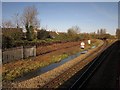
Uphill Junction
Another view of the junction shown in Image and Image, this time from a train bypassing Weston on its way from Paddington to Taunton, stopping there and diverted via Bristol because of floods, some evidence of which can be seen by the track.
Image: © Derek Harper
Taken: 23 Nov 2012
0.14 miles
3
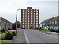
Bruton House multistorey block, Weston-super-Mare
Bruton House is an 8-storey block of 32 flats in Monkton Avenue, Oldmixon, Weston-super-Mare.
Image: © Jaggery
Taken: 27 Jul 2011
0.15 miles
4
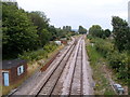
Uphill Junction, Weston-super-Mare
Viewed from Broadway, from the pedestrian bridge http://www.geograph.org.uk/photo/2653041 alongside Oldmixon Bridge.
The single line branching to the left is for Weston-super-Mare station.
Trains not stopping at Weston-super-Mare use the other lines.
Image: © Jaggery
Taken: 27 Jul 2011
0.16 miles
5
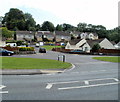
Beechmount Close and Beechmount Drive, Weston-super-Mare
In the background are Beechmount Drive houses, with Beechmount Close houses at centre right. Viewed across Broadway.
Image: © Jaggery
Taken: 27 Jul 2011
0.18 miles
6
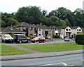
Middle section of Beechmount Close, Weston-super-Mare
Viewed across Broadway.
Image: © Jaggery
Taken: 27 Jul 2011
0.20 miles
7
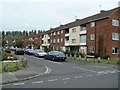
Williton Crescent, Weston-super-Mare
Flats on the SE side of Williton Crescent, viewed from Westbury Crescent.
Image: © Jaggery
Taken: 27 Jul 2011
0.20 miles
8
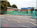
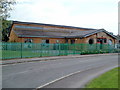
Oldmixon Primary School, Weston-super-Mare
Viewed across Monkton Avenue. There are about 240 pupils enrolled (ages 3 to 11).
Image: © Jaggery
Taken: 27 Jul 2011
0.22 miles
9
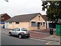
Barnabas Open Doors Centre, Oldmixon, Weston-super-Mare
Located at the western end of Aller Parade, the centre is run by St Barnabas Church, Westbury Crescent, Oldmixon.
Image: © Jaggery
Taken: 27 Jul 2011
0.22 miles
10
Oldmixon Family Centre, Weston-super-Mare
Located on Monkton Avenue, next door to Oldmixon Primary School. http://www.geograph.org.uk/photo/2562255
Image: © Jaggery
Taken: 27 Jul 2011
0.22 miles