IMAGES TAKEN NEAR TO
Cobham Parade, WESTON-SUPER-MARE, BS24 8EG
Introduction
This page details the photographs taken nearby to Cobham Parade, BS24 8EG by members of the Geograph project.
The Geograph project started in 2005 with the aim of publishing, organising and preserving representative images for every square kilometre of Great Britain, Ireland and the Isle of Man.

There are currently over 7.5m images from over14,400 individuals and you can help contribute to the project by visiting https://www.geograph.org.uk
Image Map
Images are licensed for reuse under creativecommons.org/licenses/by-sa/2.0
Notes
- Clicking on the map will re-center to the selected point.
- The higher the marker number, the further away the image location is from the centre of the postcode.
Image Listing (4 Images Found)
Images are licensed for reuse under creativecommons.org/licenses/by-sa/2.0
Image
Details
Distance
4
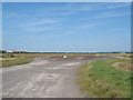
The main runway at Weston Airport
This is a picture for all of you who are air historians. As it will soon, like everything else, be covered in a new housing estate. It's the old runway looking east towards the old R.A.F Locking Camp.
Image: © Ant Basterfield
Taken: 24 Aug 2007
0.22 miles