IMAGES TAKEN NEAR TO
Beechwood Avenue, WESTON-SUPER-MARE, BS24 8DS
Introduction
This page details the photographs taken nearby to Beechwood Avenue, BS24 8DS by members of the Geograph project.
The Geograph project started in 2005 with the aim of publishing, organising and preserving representative images for every square kilometre of Great Britain, Ireland and the Isle of Man.

There are currently over 7.5m images from over14,400 individuals and you can help contribute to the project by visiting https://www.geograph.org.uk
Image Map (Loading...)


Getting Data...Please wait
Leaflet Map data © OpenStreetMap
Images are licensed for reuse under creativecommons.org/licenses/by-sa/2.0
Notes
- Clicking on the map will re-center to the selected point.
- The higher the marker number, the further away the image location is from the centre of the postcode.
Image Listing (58 Images Found)
Images are licensed for reuse under creativecommons.org/licenses/by-sa/2.0
Image
Details
Distance
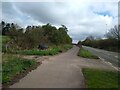
1
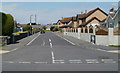
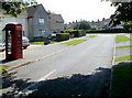
Beechwood Avenue, Locking
A view northwards from Elm Tree Road.
Image: © Jaggery
Taken: 27 Jul 2011
0.05 miles
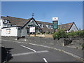
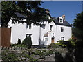
3
The Coach House, Locking
Viewed from Elm Tree Road. The village pub is in Manor Gardens.
Image: © Jaggery
Taken: 27 Jul 2011
0.11 miles
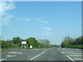
5
A371 Looking East
The A371 (Locking Moor Road) looking East towards Banwell.
Image: © s
Taken: 2 Apr 2023
0.12 miles
8
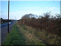
A371 from Banwell to Weston Super Mare
Image: © Adrian and Janet Quantock
Taken: 26 Nov 2005
0.15 miles
9
Byron Road, Locking
Viewed from the Elm Tree Road end.
Image: © Jaggery
Taken: 27 Jul 2011
0.15 miles
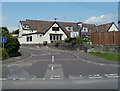
10
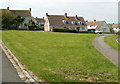
Houses facing a grass triangle, Locking
These Grenville Road houses are opposite Plumley Crescent.
Image: © Jaggery
Taken: 27 Jul 2011
0.15 miles