IMAGES TAKEN NEAR TO
Lime Close, WESTON-SUPER-MARE, BS24 8BH
Introduction
This page details the photographs taken nearby to Lime Close, BS24 8BH by members of the Geograph project.
The Geograph project started in 2005 with the aim of publishing, organising and preserving representative images for every square kilometre of Great Britain, Ireland and the Isle of Man.

There are currently over 7.5m images from over14,400 individuals and you can help contribute to the project by visiting https://www.geograph.org.uk
Image Map
Images are licensed for reuse under creativecommons.org/licenses/by-sa/2.0
Notes
- Clicking on the map will re-center to the selected point.
- The higher the marker number, the further away the image location is from the centre of the postcode.
Image Listing (55 Images Found)
Images are licensed for reuse under creativecommons.org/licenses/by-sa/2.0
Image
Details
Distance
1
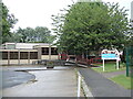
Locking Primary School
Schooling in the area had begun in the mid nineteenth century: the Parochial School opened opposite the church in 1858, paid for by subsidies from the church, the Society of Merchant Venturers and ratepayers. Pupils attended until the ravages of WWI saw numbers drop alarmingly and the school closed in 1916. Thus it remained but the military became involved once more: the air base of Locking grew in the post-WWII era and so many children needed educating closer to home. Old huts were given over to a school from 1952.
Conditions were not ideal and as numbers increased, the need to move to new premises became pressing. In 1966, fields in the village that were part of Manor Farm became the site for a new school, which was named Locking County Primary School. Anew infant facility was opened in 1972.
Image: © Neil Owen
Taken: 3 Jul 2021
0.04 miles
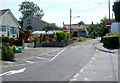
2
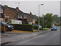
Locking : Mendip Rise
Looking along a residential road in Locking.
Image: © Lewis Clarke
Taken: 24 Jul 2015
0.05 miles
3
Locking : Mendip Rise
Mendip Rise in the town of Locking.
Image: © Lewis Clarke
Taken: 24 Jul 2015
0.05 miles
4
Locking : Old Banwell Road
Looking along Old Banwell Road from the junction at Mendip Rise.
Image: © Lewis Clarke
Taken: 24 Jul 2015
0.10 miles
5
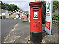
Posting in Locking
A Georgian letetrbox (by Carron) stands outside the village shop and post office.
Image: © Neil Owen
Taken: 3 Jul 2021
0.10 miles
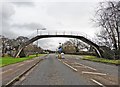
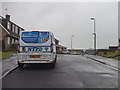
7
McCrae Road on the former RAF Locking
This road was used as an access road to the sports ground and pavilion. RAF Locking was built in 1939, and closed on 31st March 2000 at 4pm. Work to demolish the buildings on the site started in 2003 and was completed in 2004, although not all the buildings were demolished.
Image: © s
Taken: 26 Apr 2023
0.13 miles
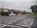
8
One-way system in Locking
An arrow painted on Elm Tree Road directs traffic to turn right into Grenville Avenue.
Image: © Jaggery
Taken: 27 Jul 2011
0.13 miles
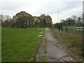
9
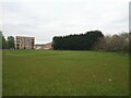
Former sports ground on the former RAF Locking
RAF Locking was built in 1939, and closed on 31st March 2000 at 4pm. Work to demolish the buildings on the site started in 2003 and was completed in 2004, although not all the buildings were demolished.
Image: © s
Taken: 26 Apr 2023
0.13 miles
10
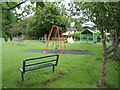
Play area in Locking
Some equipment in a large open space for the little ones and a seat for the slightly older.
Image: © Neil Owen
Taken: 3 Jul 2021
0.14 miles