IMAGES TAKEN NEAR TO
Cruikshank Grove, WESTON-SUPER-MARE, BS24 7NL
Introduction
This page details the photographs taken nearby to Cruikshank Grove, BS24 7NL by members of the Geograph project.
The Geograph project started in 2005 with the aim of publishing, organising and preserving representative images for every square kilometre of Great Britain, Ireland and the Isle of Man.

There are currently over 7.5m images from over14,400 individuals and you can help contribute to the project by visiting https://www.geograph.org.uk
Image Map (Loading...)


Getting Data...Please wait
Leaflet Map data © OpenStreetMap
Images are licensed for reuse under creativecommons.org/licenses/by-sa/2.0
Notes
- Clicking on the map will re-center to the selected point.
- The higher the marker number, the further away the image location is from the centre of the postcode.
Image Listing (59 Images Found)
Images are licensed for reuse under creativecommons.org/licenses/by-sa/2.0
Image
Details
Distance
1
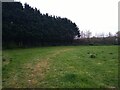
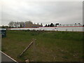
Former sports ground on the former RAF Locking
RAF Locking was built in 1939, and closed on 31st March 2000 at 4pm. Work to demolish the buildings on the site started in 2003 and was completed in 2004, although not all the buildings were demolished.
Image: © s
Taken: 26 Apr 2023
0.04 miles
2
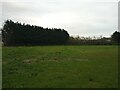
Former sports ground on the former RAF Locking
RAF Locking was built in 1939, and closed on 31st March 2000 at 4pm. Work to demolish the buildings on the site started in 2003 and was completed in 2004, although not all the buildings were demolished.
Image: © s
Taken: 26 Apr 2023
0.04 miles
3
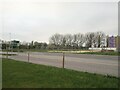
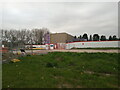
Former sports ground on the former RAF Locking
Apprentice Way cuts the former sports ground in half. On the right is the new Winterstoke Hundred Academy secondary school being built. RAF Locking was built in 1939, and closed on 31st March 2000 at 4pm. Work to demolish the buildings on the site started in 2003 and was completed in 2004, although not all the buildings were demolished.
Image: © s
Taken: 26 Apr 2023
0.05 miles
4
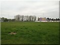
Former sports ground on the former RAF Locking
RAF Locking was built in 1939, and closed on 31st March 2000 at 4pm. Work to demolish the buildings on the site started in 2003 and was completed in 2004, although not all the buildings were demolished. In the background is the new Winterstoke Hundred Academy secondary school being built.
Image: © s
Taken: 26 Apr 2023
0.05 miles
5
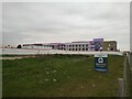
Winterstoke Hundred Academy secondary school in construction
Image: © s
Taken: 26 Apr 2023
0.06 miles
6
Winterstoke Hundred Academy secondary school in construction
Image: © s
Taken: 26 Apr 2023
0.06 miles
7
Winterstoke Hundred Academy secondary school in construction
Image: © s
Taken: 26 Apr 2023
0.06 miles
8
Apprentice Way and the former sports ground on the former RAF Locking
RAF Locking was built in 1939, and closed on 31st March 2000 at 4pm. Work to demolish the buildings on the site started in 2003 and was completed in 2004, although not all the buildings were demolished.
Apprentice Way cuts the former sports ground in two. Apprentice Way is currently being built as a link road from the A371 Locking Moor Road to the A370 West Wick Roundabout. On the left, Cruikshank Grove leads into the Locking Parklands housing estate. The road to the right will give access to Winterstoke Hundred Academy secondary school, which is currently in construction.
Image: © s
Taken: 26 Apr 2023
0.06 miles
9
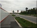
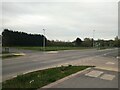
Apprentice Way looking Northeast
On the left is the new Winterstoke Hundred Academy secondary school being built.
Image: © s
Taken: 26 Apr 2023
0.06 miles
10
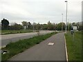
Apprentice Way looking South
Towards the junction with the A371 Locking Moor Road
Image: © s
Taken: 26 Apr 2023
0.07 miles