IMAGES TAKEN NEAR TO
Cranwell Road, WESTON-SUPER-MARE, BS24 7LU
Introduction
This page details the photographs taken nearby to Cranwell Road, BS24 7LU by members of the Geograph project.
The Geograph project started in 2005 with the aim of publishing, organising and preserving representative images for every square kilometre of Great Britain, Ireland and the Isle of Man.

There are currently over 7.5m images from over14,400 individuals and you can help contribute to the project by visiting https://www.geograph.org.uk
Image Map
Images are licensed for reuse under creativecommons.org/licenses/by-sa/2.0
Notes
- Clicking on the map will re-center to the selected point.
- The higher the marker number, the further away the image location is from the centre of the postcode.
Image Listing (39 Images Found)
Images are licensed for reuse under creativecommons.org/licenses/by-sa/2.0
Image
Details
Distance
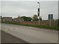
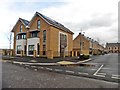
1
Housing development at Locking Parklands
Image: © Roger Cornfoot
Taken: 31 Jan 2018
0.05 miles
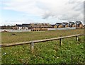
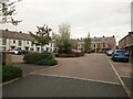
3
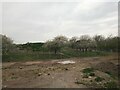
Site of the apprentices' barracks on the former RAF Locking
RAF Locking was built in 1939, and closed on 31st March 2000 at 4pm. Work to demolish the buildings on the site started in 2003 and was completed in 2004, although not all the buildings were demolished.
Image: © s
Taken: 26 Apr 2023
0.07 miles
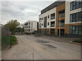
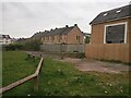
6
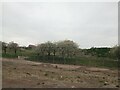
Former RAF Locking
Looking towards Bowen Road.
RAF Locking was built in 1939, and closed on 31st March 2000 at 4pm. Work to demolish the buildings on the site started in 2003 and was completed in 2004, although not all the buildings were demolished.
Image: © s
Taken: 26 Apr 2023
0.09 miles
8
Former RAF Locking
Looking towards Bowen Road.
RAF Locking was built in 1939, and closed on 31st March 2000 at 4pm. Work to demolish the buildings on the site started in 2003 and was completed in 2004, although not all the buildings were demolished.
Image: © s
Taken: 26 Apr 2023
0.11 miles
9
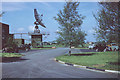
R.A.F. No.1 Radio School, Locking, Somerset
This establishment trained Royal Air Force apprentices and other ranks in the black art of radio location. The featured radar scanner was U.S. equipment and nick-named the "Nodding Horror" due to its frenetic motion. The green huts in the distance were the airmen's billets. The photographer had just finished his 28 week training course and was due for posting.
Image: © Geoff Royle
Taken: Unknown
0.11 miles