IMAGES TAKEN NEAR TO
Bodley Way, WESTON-SUPER-MARE, BS24 7HD
Introduction
This page details the photographs taken nearby to Bodley Way, BS24 7HD by members of the Geograph project.
The Geograph project started in 2005 with the aim of publishing, organising and preserving representative images for every square kilometre of Great Britain, Ireland and the Isle of Man.

There are currently over 7.5m images from over14,400 individuals and you can help contribute to the project by visiting https://www.geograph.org.uk
Image Map (Loading...)


Getting Data...Please wait
Leaflet Map data © OpenStreetMap
Images are licensed for reuse under creativecommons.org/licenses/by-sa/2.0
Notes
- Clicking on the map will re-center to the selected point.
- The higher the marker number, the further away the image location is from the centre of the postcode.
Image Listing (38 Images Found)
Images are licensed for reuse under creativecommons.org/licenses/by-sa/2.0
Image
Details
Distance
1
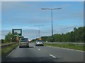
Approaching Airport Roundabout
Looking westward.
Image: © Ruth Riddle
Taken: 17 Jul 2012
0.08 miles
2
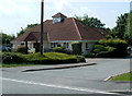
Green Pastures Veterinary Centre, Weston-super-Mare
Viewed from the corner of Moor Lane and Stormont Court.
Image: © Jaggery
Taken: 27 Jul 2011
0.08 miles
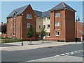
3
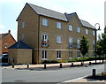
Flats on the corner of Careys Way and Carousel Lane, Weston-super-Mare
Image: © Jaggery
Taken: 27 Jul 2011
0.09 miles
4
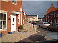
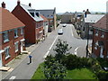
Longridge Way, Weston Village
Part of the ever growing 'suburbia' of Weston Super Mare
Image: © Adrian and Janet Quantock
Taken: 25 Nov 2005
0.10 miles
5
Worle Moor Road houses, Weston-super-Mare
Viewed from a footbridge http://www.geograph.org.uk/photo/3105464 across the railway.
Image: © Jaggery
Taken: 27 Jul 2011
0.14 miles
6
Clarence and Kensington, Stormont Court, Weston-super-Mare
This is the eastern side of a block of 24 flats, divided into 4 separately named groups of six flats.
In view are Clarence and Kensington. The other two groups are St James and Glamis.
Image: © Jaggery
Taken: 27 Jul 2011
0.14 miles
7
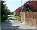
Cycle route, Stormont Court, Weston-super-Mare
Cylindrical concrete posts block the way ahead for anything wider than a 2-wheel vehicle.
Image: © Jaggery
Taken: 27 Jul 2011
0.14 miles
8
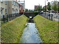
Footbridge over a rhyne, Griffen Road, Locking Castle, Weston-super-Mare
Rhyne is the local word for a drainage channel.
Image: © Jaggery
Taken: 27 Jul 2011
0.15 miles
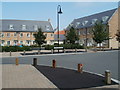
9
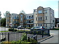
Corner of Moor Lane and Griffen Road, Locking Castle, Weston-super-Mare
The corner site is occupied by a three-storey block of flats.
Image: © Jaggery
Taken: 27 Jul 2011
0.15 miles
10
Worle Moor Road, Weston-super-Mare
Viewed from Carousel Lane.
Image: © Jaggery
Taken: 27 Jul 2011
0.16 miles