IMAGES TAKEN NEAR TO
Darmead, WESTON-SUPER-MARE, BS24 7EH
Introduction
This page details the photographs taken nearby to Darmead, BS24 7EH by members of the Geograph project.
The Geograph project started in 2005 with the aim of publishing, organising and preserving representative images for every square kilometre of Great Britain, Ireland and the Isle of Man.

There are currently over 7.5m images from over14,400 individuals and you can help contribute to the project by visiting https://www.geograph.org.uk
Image Map (Loading...)


Getting Data...Please wait
Leaflet Map data © OpenStreetMap
Images are licensed for reuse under creativecommons.org/licenses/by-sa/2.0
Notes
- Clicking on the map will re-center to the selected point.
- The higher the marker number, the further away the image location is from the centre of the postcode.
Image Listing (136 Images Found)
Images are licensed for reuse under creativecommons.org/licenses/by-sa/2.0
Image
Details
Distance
1
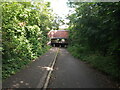
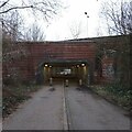
Summer Lane Subway
Summer Lane Subway opened in July 1995, along with the A370 Somerset Avenue. It closed to motor traffic in the 2000s.
The design for the wall tiling in the subway was produced by a student from the Creative Arts and Design Group of Weston-super-Mare College. The theme of the design is "Earth, Wind. Fire and Water" into which several local features have been introduced. The "Motte and Bailey" symbol represents the earthworks found near Locking Heard Farm from which Locking Castle has taken its name. The inclusion of the RAF target symbolises the long association with flying in the area.
Image: © s
Taken: 1 Aug 2021
0.04 miles
2
Darmead looking South
Darmead was built in 1995-1996 as part of the Locking Castle development which is the largest housing estate in Weston-super-Mare.
Image: © s
Taken: 30 Mar 2023
0.05 miles
3
Summer Lane Subway
Summer Lane Subway opened in July 1995, along with the A370 Somerset Avenue. It closed to motor traffic in the 2000s.
The design for the wall tiling in the subway was produced by a student from the Creative Arts and Design Group of Weston-super-Mare College. The theme of the design is "Earth, Wind. Fire and Water" into which several local features have been introduced. The "Motte and Bailey" symbol represents the earthworks found near Locking Heard Farm from which Locking Castle has taken its name. The inclusion of the RAF target symbolises the long association with flying in the area.
Image: © s
Taken: 9 Feb 2021
0.05 miles
4
Yarbury Way looking West
Yarbury Way was built in 1995-1996 as part of the Locking Castle development which is the largest housing estate in Weston-super-Mare.
Image: © s
Taken: 30 Mar 2023
0.05 miles
5
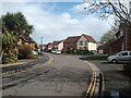
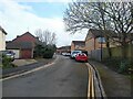
Yarbury Way looking Southeast
Yarbury Way was built in 1995-1996 as part of the Locking Castle development which is the largest housing estate in Weston-super-Mare. The road leading right is Darmead, a residential street built at the same time as Yarbury Way.
Image: © s
Taken: 30 Mar 2023
0.06 miles
6
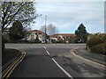
Yarbury Way and Diamond Batch junction
Junction of Yarbury Way and Diamond Batch. Yarbury Way and this section of Diamond Batch was built in 1995-1996 as part of the Locking Castle development which is the largest housing estate in Weston-super-Mare.
Image: © s
Taken: 30 Mar 2023
0.06 miles
7
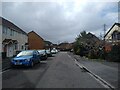
Diamond Batch looking Northeast
Diamond Batch looking Northeast on the corner of Yarbury Way. Yarbury Way and this section of Diamond Batch was built in 1995-1996 as part of the Locking Castle development.
Image: © s
Taken: 30 Mar 2023
0.07 miles
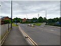
8
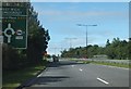
Approaching West Wick Roundabout
Looking south-west along the A370
Image: © Ruth Riddle
Taken: 17 Jul 2012
0.07 miles
9
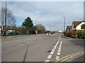
Diamond Batch looking Southwest
This section of Diamond Batch from Summer Lane to The Coast Resource Centre was built in 1996. Diamond Batch was extended in 2012.
The flats in the background on Elmham Way were built in 2005.
Image: © s
Taken: 14 May 2023
0.07 miles
10

Diamond Batch looking Southwest
This section of Diamond Batch from Summer Lane to The Coast Resource Centre was built in 1996. Diamond Batch was extended in 2012.
The houses on the left at Yarbury Way were built in 1996.
Image: © s
Taken: 14 May 2023
0.07 miles