IMAGES TAKEN NEAR TO
Kempe Way, WESTON-SUPER-MARE, BS24 7DZ
Introduction
This page details the photographs taken nearby to Kempe Way, BS24 7DZ by members of the Geograph project.
The Geograph project started in 2005 with the aim of publishing, organising and preserving representative images for every square kilometre of Great Britain, Ireland and the Isle of Man.

There are currently over 7.5m images from over14,400 individuals and you can help contribute to the project by visiting https://www.geograph.org.uk
Image Map (Loading...)


Getting Data...Please wait
Leaflet Map data © OpenStreetMap
Images are licensed for reuse under creativecommons.org/licenses/by-sa/2.0
Notes
- Clicking on the map will re-center to the selected point.
- The higher the marker number, the further away the image location is from the centre of the postcode.
Image Listing (19 Images Found)
Images are licensed for reuse under creativecommons.org/licenses/by-sa/2.0
Image
Details
Distance
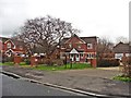
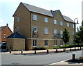
1
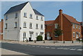
Houses on the corner of Moor Lane and Griffen Road, Locking Castle, Weston-super-Mare
These houses on the NE corner of Moor Lane and Griffen Road are opposite flats http://www.geograph.org.uk/photo/3105256 on the NW corner.
Image: © Jaggery
Taken: 27 Jul 2011
0.07 miles
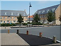
2
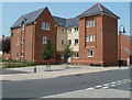
Corner of Moor Lane and Griffen Road, Locking Castle, Weston-super-Mare
The corner site is occupied by a three-storey block of flats.
Image: © Jaggery
Taken: 27 Jul 2011
0.08 miles
4
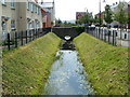
Footbridge over a rhyne, Griffen Road, Locking Castle, Weston-super-Mare
Rhyne is the local word for a drainage channel.
Image: © Jaggery
Taken: 27 Jul 2011
0.11 miles
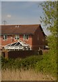
6
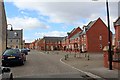
Worle Moor Road
Modern urban infill estate.
Image: © Bob Embleton
Taken: 5 Mar 2012
0.14 miles
7
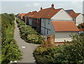
Heligan Walk, Weston-super-Mare
Viewed from the access ramp http://www.geograph.org.uk/photo/3105475 to a railway footbridge. The line of trees on the left shield the houses from the adjacent railway.
Image: © Jaggery
Taken: 27 Jul 2011
0.15 miles
8
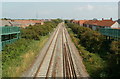
A view NE from a railway footbridge, Weston-super-Mare
Viewed from this http://www.geograph.org.uk/photo/3105464 footbridge. This is the route used by trains that bypass Weston-super-Mare railway station. Worle Junction is ahead, where trains for the station diverge from the main line.
Image: © Jaggery
Taken: 27 Jul 2011
0.16 miles
9
Worle Moor Road, Weston-super-Mare
Viewed from Carousel Lane.
Image: © Jaggery
Taken: 27 Jul 2011
0.20 miles
10
Flats on the corner of Careys Way and Carousel Lane, Weston-super-Mare
Image: © Jaggery
Taken: 27 Jul 2011
0.21 miles