IMAGES TAKEN NEAR TO
Trenchard Road, WESTON-SUPER-MARE, BS24 7AH
Introduction
This page details the photographs taken nearby to Trenchard Road, BS24 7AH by members of the Geograph project.
The Geograph project started in 2005 with the aim of publishing, organising and preserving representative images for every square kilometre of Great Britain, Ireland and the Isle of Man.

There are currently over 7.5m images from over14,400 individuals and you can help contribute to the project by visiting https://www.geograph.org.uk
Image Map (Loading...)


Getting Data...Please wait
Leaflet Map data © OpenStreetMap
Images are licensed for reuse under creativecommons.org/licenses/by-sa/2.0
Notes
- Clicking on the map will re-center to the selected point.
- The higher the marker number, the further away the image location is from the centre of the postcode.
Image Listing (25 Images Found)
Images are licensed for reuse under creativecommons.org/licenses/by-sa/2.0
Image
Details
Distance
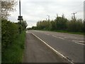
2
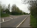
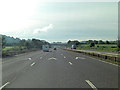
Old Direction Sign - Signpost by Locking Moor Road, Locking
Pyramid finial - 2 arms; Somerset SCC pyramid by the A371, in parish of Locking (North Somerset District), junction with road to Hillend.
Surveyed
Milestone Society National ID: SO_ST3759A
Image: © Milestone Society
Taken: Unknown
0.11 miles
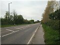
4
Flowerdown Road looking West
This area is called Locking Grove and is the former Officer's quarters on RAF Locking.
RAF Locking was built in 1939, and closed on 31st March 2000 at 4pm. Work to demolish the buildings on the site started in 2003 and was completed in 2004, although not all the buildings were demolished.
Image: © s
Taken: 26 Apr 2023
0.13 miles
6
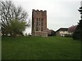
Former water tower on the former RAF Locking
The former water tower was built in the 1940s. The Ministry of Defence sold the tower in 2008 to a local, who planned to turn it into a house.
RAF Locking was built in 1939, and closed on 31st March 2000 at 4pm. Work to demolish the buildings on the site started in 2003 and was completed in 2004, although not all the buildings were demolished.
Image: © s
Taken: 26 Apr 2023
0.14 miles
7
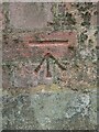
Ordnance Survey bench mark
On the water tower of the former RAF Locking.
The former water tower was built in the 1940s. The Ministry of Defence sold the tower in 2008 to a local, who planned to turn it into a house.
RAF Locking was built in 1939, and closed on 31st March 2000 at 4pm. Work to demolish the buildings on the site started in 2003 and was completed in 2004, although not all the buildings were demolished.
Image: © s
Taken: 26 Apr 2023
0.14 miles
8
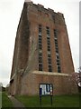
Former water tower on the former RAF Locking
The former water tower was built in the 1940s. The Ministry of Defence sold the tower in 2008 to a local, who planned to turn it into a house.
RAF Locking was built in 1939, and closed on 31st March 2000 at 4pm. Work to demolish the buildings on the site started in 2003 and was completed in 2004, although not all the buildings were demolished.
Image: © s
Taken: 26 Apr 2023
0.15 miles
10
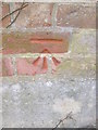
Ordnance Survey Cut Mark
This OS cut mark can be found on the NE face of the water tower. It marks a point 27.725m above mean sea level.
Image: © Adrian Dust
Taken: 16 Mar 2016
0.15 miles