IMAGES TAKEN NEAR TO
Way Wick, Hewish, WESTON-SUPER-MARE, BS24 6UZ
Introduction
This page details the photographs taken nearby to BS24 6UZ by members of the Geograph project.
The Geograph project started in 2005 with the aim of publishing, organising and preserving representative images for every square kilometre of Great Britain, Ireland and the Isle of Man.

There are currently over 7.5m images from over14,400 individuals and you can help contribute to the project by visiting https://www.geograph.org.uk
Image Map
Images are licensed for reuse under creativecommons.org/licenses/by-sa/2.0
Notes
- Clicking on the map will re-center to the selected point.
- The higher the marker number, the further away the image location is from the centre of the postcode.
Image Listing (7 Images Found)
Images are licensed for reuse under creativecommons.org/licenses/by-sa/2.0
Image
Details
Distance
2
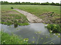
Access ramp for cattle to drink from the River Banwell
Image: © Dr Duncan Pepper
Taken: 20 May 2011
0.19 miles
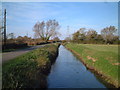
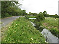
3
Rhyne, Rolstone
A minor road runs between two rhynes.
Image: © Richard Webb
Taken: 18 Apr 2011
0.20 miles
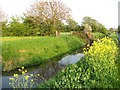
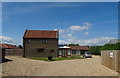
4
The River Banwell
Crossed at this point by a 20'' water main.
Image: © Dr Duncan Pepper
Taken: 20 May 2011
0.20 miles
6
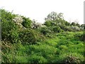
Unused field
Across the M5 from fast expanding Weston, this field has not seen much in the way of grazing for some time. Gradually it is being colonised by thorns and briars.
Image: © Richard Webb
Taken: 18 Apr 2011
0.21 miles