IMAGES TAKEN NEAR TO
Hewish, WESTON-SUPER-MARE, BS24 6RA
Introduction
This page details the photographs taken nearby to BS24 6RA by members of the Geograph project.
The Geograph project started in 2005 with the aim of publishing, organising and preserving representative images for every square kilometre of Great Britain, Ireland and the Isle of Man.

There are currently over 7.5m images from over14,400 individuals and you can help contribute to the project by visiting https://www.geograph.org.uk
Image Map (Loading...)


Getting Data...Please wait
Leaflet Map data © OpenStreetMap
Images are licensed for reuse under creativecommons.org/licenses/by-sa/2.0
Notes
- Clicking on the map will re-center to the selected point.
- The higher the marker number, the further away the image location is from the centre of the postcode.
Image Listing (29 Images Found)
Images are licensed for reuse under creativecommons.org/licenses/by-sa/2.0
Image
Details
Distance
1

Drainage channel near Weston-super-Mare
Drainage channels, locally called rhynes, are a common sight in this part of North Somerset, draining the flat, low-lying North Somerset Levels.
This view was taken on the north side of the A370, near M5 motorway junction 21.
Image: © Jaggery
Taken: 23 Jul 2011
0.11 miles
2

Silver Moor Lane near Weston-super-Mare
Viewed across the A370 about 450 metres NE of M5 motorway junction.
Silver Moor Lane heads towards Way Wick.
Image: © Jaggery
Taken: 23 Jul 2011
0.12 miles
3

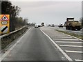
Postbox in A370 layby near Weston-super-Mare
The layby, with a postbox on a stand, is on the north side of the A370
about 500 metres NE of M5 motorway junction 21.
Image: © Jaggery
Taken: 23 Jul 2011
0.12 miles
4
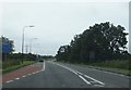
The A370 near Junction 21 of the M5
Approaching the motorway junction heading west, the start of a peak-hours bus lane is pictured.
Image: © Ruth Riddle
Taken: 17 Jul 2012
0.13 miles
5

A370 approaches M5 motorway junction 21 near Weston-super-Mare
The A370 from Hewish approaches the eastern edge of Weston-super-Mare.
Image: © Jaggery
Taken: 23 Jul 2011
0.13 miles
6
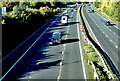
M5 northbound
Junction 21 - Weston-super-Mare
Image: © Anthony O'Neil
Taken: 10 Oct 2022
0.14 miles
7
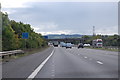
M5 near Junction 21
At marker 164.5 southbound.
Image: © J.Hannan-Briggs
Taken: 22 Sep 2015
0.14 miles
9

New-style and old-style signs opposite West Rolstone Road near Weston-super-Mare
Viewed along the A370. http://www.geograph.org.uk/photo/3038020 for another view of the old-style signs.
Image: © Jaggery
Taken: 23 Jul 2011
0.17 miles
10

Old-style signpost at the northern end of West Rolstone Road near Weston-super-Mare
There are three arms on the signpost. One points left along the A370 towards Congresbury and Bristol. The one pointing along the A370 in the opposite direction shows Weston-s(uper)-Mare and Bridgwater. The third arm points across the A370 towards Rolstone along West Rolstone Road. http://www.geograph.org.uk/photo/3037990
Image: © Jaggery
Taken: 23 Jul 2011
0.17 miles