IMAGES TAKEN NEAR TO
West Rolstone Road, WESTON-SUPER-MARE, BS24 6AJ
Introduction
This page details the photographs taken nearby to West Rolstone Road, BS24 6AJ by members of the Geograph project.
The Geograph project started in 2005 with the aim of publishing, organising and preserving representative images for every square kilometre of Great Britain, Ireland and the Isle of Man.

There are currently over 7.5m images from over14,400 individuals and you can help contribute to the project by visiting https://www.geograph.org.uk
Image Map (Loading...)


Getting Data...Please wait
Leaflet Map data © OpenStreetMap
Images are licensed for reuse under creativecommons.org/licenses/by-sa/2.0
Notes
- Clicking on the map will re-center to the selected point.
- The higher the marker number, the further away the image location is from the centre of the postcode.
Image Listing (9 Images Found)
Images are licensed for reuse under creativecommons.org/licenses/by-sa/2.0
Image
Details
Distance
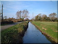
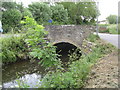
4
Bridge off Silver Moor Lane, West Rolstone
Bridge over the River Banwell at Silver Moor Lane.
Silver Moor Lane is on the left, the lane on the right going through West Rolstone is unnamed.
Photograph taken north looking downstream on the river.
Image: © Kevin Pearson
Taken: 17 Jan 2021
0.15 miles
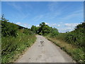
5
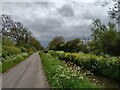
Lane from Rolstone looking towards Silver Moor Bridge
Unnamed lane which links West Rolstone Road with Silver Moor Lane, looking south towards bridge over the River Banwell by the junction of the lanes.
Image: © Kevin Pearson
Taken: 18 May 2021
0.17 miles
6
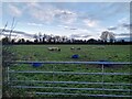
Sheep in a field near West Rolstone
Flock of sheep in a field by the River Banwell near West Rolstone.
Image: © Kevin Pearson
Taken: 29 Dec 2020
0.18 miles
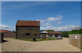
7
Bridge over the River Banwell at Waterloo Farm
Image: © Dr Duncan Pepper
Taken: 20 May 2011
0.18 miles
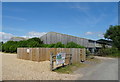
8
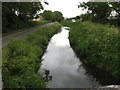
The River Banwell at Waterloo Farm
Image: © Dr Duncan Pepper
Taken: 20 May 2011
0.22 miles