IMAGES TAKEN NEAR TO
Old Church Road, WESTON-SUPER-MARE, BS23 4XL
Introduction
This page details the photographs taken nearby to Old Church Road, BS23 4XL by members of the Geograph project.
The Geograph project started in 2005 with the aim of publishing, organising and preserving representative images for every square kilometre of Great Britain, Ireland and the Isle of Man.

There are currently over 7.5m images from over14,400 individuals and you can help contribute to the project by visiting https://www.geograph.org.uk
Image Map (Loading...)


Getting Data...Please wait
Leaflet Map data © OpenStreetMap
Images are licensed for reuse under creativecommons.org/licenses/by-sa/2.0
Notes
- Clicking on the map will re-center to the selected point.
- The higher the marker number, the further away the image location is from the centre of the postcode.
Image Listing (173 Images Found)
Images are licensed for reuse under creativecommons.org/licenses/by-sa/2.0
Image
Details
Distance
1
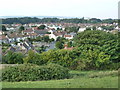
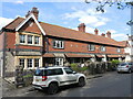
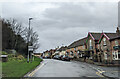
Old Church Road and view from the hill, Uphill
Image: © Ruth Sharville
Taken: 4 Sep 2010
0.02 miles
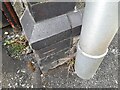
2
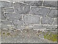
Ordnance Survey Cut Mark
This OS cut mark can be found on the west parapet of the bridge. It marks a point 5.852m above mean sea level
Image: © Adrian Dust
Taken: 31 Jul 2023
0.02 miles
3
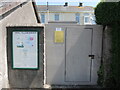
Village news on Westfield Close
The noticeboard happens to be next to a substation, both are on part of the grounds of Westfield House.
Image: © Neil Owen
Taken: 24 May 2023
0.05 miles
4
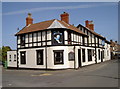
The Dolphin
Suitably thirsty and with a jar in its surprisingly dextrous flipper, the Dolphin welcomes visitors to Uphill.
Image: © Neil Owen
Taken: 16 Apr 2013
0.06 miles
5
Yniship Terrace
A striking terrace built in 1911.
Image: © Neil Owen
Taken: 25 Apr 2023
0.06 miles
6
Ordnance Survey Cut Mark
This OS cut mark can be found on the gatepost of the Dolphin PH on Uphill Way. It marks a point 6.325m above mean sea level
Image: © Adrian Dust
Taken: 31 Jul 2023
0.06 miles
7
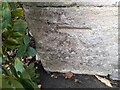
Ordnance Survey Cut Mark
This OS cut mark can be found on the north face of the school. It marks a point 6.325m above mean sea level
Image: © Adrian Dust
Taken: 31 Jul 2023
0.07 miles
8
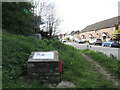
Uphill's cannon
This block marks the site where a weapon of war once stood. After WWI a German Minenwerfer (literally 'mine thrower') was captured and placed here. It was a stubby barrel mounted on two large cartwheels, and a popular plaything for local children. As WWII broke out, it was removed.
Image: © Neil Owen
Taken: 25 Apr 2023
0.07 miles
9
On Uphill Way at the junction with Old Church Road
Image: © Rob Purvis
Taken: 8 Jan 2022
0.07 miles
10
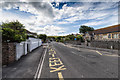
Old Church Road, Uphill
View south along Old Church Road with Uphill Community Primary School on the right.
Image: © David P Howard
Taken: 6 Jul 2016
0.07 miles