IMAGES TAKEN NEAR TO
Grange Road, WESTON-SUPER-MARE, BS23 4TD
Introduction
This page details the photographs taken nearby to Grange Road, BS23 4TD by members of the Geograph project.
The Geograph project started in 2005 with the aim of publishing, organising and preserving representative images for every square kilometre of Great Britain, Ireland and the Isle of Man.

There are currently over 7.5m images from over14,400 individuals and you can help contribute to the project by visiting https://www.geograph.org.uk
Image Map (Loading...)


Getting Data...Please wait
Leaflet Map data © OpenStreetMap
Images are licensed for reuse under creativecommons.org/licenses/by-sa/2.0
Notes
- Clicking on the map will re-center to the selected point.
- The higher the marker number, the further away the image location is from the centre of the postcode.
Image Listing (27 Images Found)
Images are licensed for reuse under creativecommons.org/licenses/by-sa/2.0
Image
Details
Distance
2
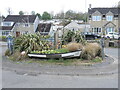
All at sea in Uphill
The Uphill Road South roundabout has some nautical themes.
Image: © Neil Owen
Taken: 25 Apr 2023
0.02 miles
3
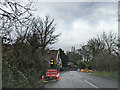
Folly Lane goes uphill
The short lane is a good place to park up and get the boots on: Uphill is a popular walking area, with paths that go uphill to Uphill Hill, of course. Inside the narrow sliver of grass is a memorial bench.
Image: © Neil Owen
Taken: 25 Apr 2023
0.07 miles
5
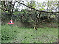
Falling rock on Uphill
A small section of worked stone extraction has a standard warning sign, even though this is not a road accessible to motor traffic.
Image: © Neil Owen
Taken: 25 Apr 2023
0.10 miles
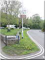
7
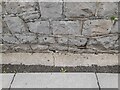
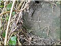
Ordnance Survey Cut Mark
This OS cut mark can be found on the east parapet of the bridge. It marks a point 6.143m above mean sea level
Image: © Adrian Dust
Taken: 31 Jul 2023
0.13 miles
8
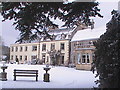
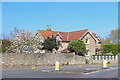
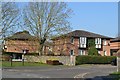
Uphill Grange in the snow
1700s gentlemans residence extended in 1900s and 1980s
A former Muller Orphanage in the 60s/70s now a nursing home with fine views of
Weston-super-Mare, Brent Knoll and The River Axe
Image: © Dave Roxburgh
Taken: 2 Feb 2009
0.14 miles
9
Ordnance Survey Cut Mark
This OS cut mark can be found on the wall SW side of Uphill Way. It marks a point 7.276m above mean sea level
Image: © Adrian Dust
Taken: 31 Jul 2023
0.15 miles