IMAGES TAKEN NEAR TO
Moseley Grove, WESTON-SUPER-MARE, BS23 4SF
Introduction
This page details the photographs taken nearby to Moseley Grove, BS23 4SF by members of the Geograph project.
The Geograph project started in 2005 with the aim of publishing, organising and preserving representative images for every square kilometre of Great Britain, Ireland and the Isle of Man.

There are currently over 7.5m images from over14,400 individuals and you can help contribute to the project by visiting https://www.geograph.org.uk
Image Map (Loading...)


Getting Data...Please wait
Leaflet Map data © OpenStreetMap
Images are licensed for reuse under creativecommons.org/licenses/by-sa/2.0
Notes
- Clicking on the map will re-center to the selected point.
- The higher the marker number, the further away the image location is from the centre of the postcode.
Image Listing (35 Images Found)
Images are licensed for reuse under creativecommons.org/licenses/by-sa/2.0
Image
Details
Distance
1
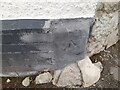
Ordnance Survey Cut Mark
This damaged OS cut mark can be found on No35 Uphill Road. It marks a point 7.990m above mean sea level
Image: © Adrian Dust
Taken: 31 Jul 2023
0.09 miles
2
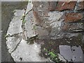
Ordnance Survey Cut Mark
This OS cut mark can be found on the SE angle of St Nicholas Church. It marks a point 9.113m above mean sea level
Image: © Adrian Dust
Taken: 31 Jul 2023
0.09 miles
3
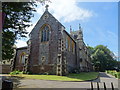
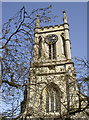
Church of St Nicholas, Uphill
Nineteenth century church replacing an earlier one - Image] which is still extant.
Image: © JThomas
Taken: 12 Jul 2019
0.10 miles
4
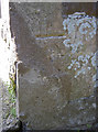
A new benchmark for a new church
St Nicholas new church was originally smaller, but had extensions added. A benchmark was cut into the north side of the tower in the mid-1800s, but was covered up with the new work. So hence a new benchmark was made in the opposite side of the church here in the southeast corner and appears on maps from 1903 onwards. See http://www.bench-marks.org.uk/bm39400 for the entry in the Benchmark Database and Image] for a look at the extensions.
Image: © Neil Owen
Taken: 18 Apr 2013
0.10 miles
5
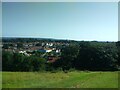
View from the top of Uphill hill
Looking toward Uphill village and St Nicholas Church.
Image: © Ant Basterfield
Taken: 18 Jul 2021
0.10 miles
6
Church of Saint Nicholas, Uphill Road South
It is a grade II listed building whose nave and west tower was built in 1844 by J Wilson with the chancel added in 1892 http://www.britishlistedbuildings.co.uk/en-33246-church-of-saint-nicholas-weston-super-mar#.VztZOcv2bcc
Image: © John Baker
Taken: 7 Apr 2016
0.10 miles
7
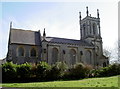
St Nicholas the New!
Uphill had a church right on top of the hill, and a place of worship probably since Saxon times. However, a new one was built in the nineteenth century on the lower levels. Sadly the original fell into disuse and partial ruin. However this one still has a roof. Looking closer and it can be seen the newer part of the eastern (to left of shot) end to be made of pennant stone. There used to be an original bolt benchmark in the tower but was covered up. To replace it a fresh one was cut into the new section - see Image
See Image] for more views of St Nich.
Image: © Neil Owen
Taken: 16 Apr 2013
0.10 miles
8
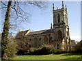
St Nicholas on Uphill Road South
This church is of Victorian vintage, with additional work carried out to extend it about the turn of the century. See Image] for more views.
Image: © Neil Owen
Taken: 18 Apr 2013
0.10 miles
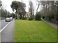
10
A late blossom
The cold spring of 2013 has delayed the pink flowering so often associated with churchyards. See Image] for another look at St Nicholas.
Image: © Neil Owen
Taken: 18 Apr 2013
0.11 miles