IMAGES TAKEN NEAR TO
Porlock Close, WESTON-SUPER-MARE, BS23 4RQ
Introduction
This page details the photographs taken nearby to Porlock Close, BS23 4RQ by members of the Geograph project.
The Geograph project started in 2005 with the aim of publishing, organising and preserving representative images for every square kilometre of Great Britain, Ireland and the Isle of Man.

There are currently over 7.5m images from over14,400 individuals and you can help contribute to the project by visiting https://www.geograph.org.uk
Image Map (Loading...)


Getting Data...Please wait
Leaflet Map data © OpenStreetMap
Images are licensed for reuse under creativecommons.org/licenses/by-sa/2.0
Notes
- Clicking on the map will re-center to the selected point.
- The higher the marker number, the further away the image location is from the centre of the postcode.
Image Listing (31 Images Found)
Images are licensed for reuse under creativecommons.org/licenses/by-sa/2.0
Image
Details
Distance
1
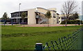
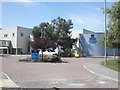
Weston College University Campus buildings, Weston-super-Mare
Viewed from Loxton Road. The University Campus opened in 2007. It houses arts, media, design and music sections, and a Sixth Form Centre. Degree-level education is provided in partnership with Bath Spa University.
Image: © Jaggery
Taken: 27 Jul 2011
0.06 miles
2
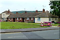
Christon Terrace bungalows, Weston-super-Mare
The western half of Christon Terrace, viewed from Loxton Road. The far side of Christon Terrace, out of shot, ends near Westbury Crescent.
Image: © Jaggery
Taken: 27 Jul 2011
0.07 miles
3
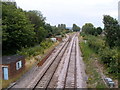
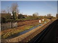
Uphill Junction, Weston-super-Mare
Viewed from Broadway, from the pedestrian bridge http://www.geograph.org.uk/photo/2653041 alongside Oldmixon Bridge.
The single line branching to the left is for Weston-super-Mare station.
Trains not stopping at Weston-super-Mare use the other lines.
Image: © Jaggery
Taken: 27 Jul 2011
0.08 miles
4
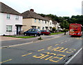
Loxton Road houses, Weston-super-Mare
Looking in the direction of the left turn into Westbury Crescent. There are no houses on the camera side of the road along this section of Loxton Road. On the north side of fields occupying the southernmost section is Weston College University Campus.
Image: © Jaggery
Taken: 27 Jul 2011
0.09 miles
5
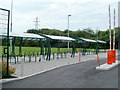
Sheltered bicycle racks, Weston College, Weston-super-Mare
Located at the southern edge of the college's University Campus, Loxton Road.
Image: © Jaggery
Taken: 27 Jul 2011
0.09 miles
7
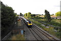
An evening local train pulls out to mainline
This southbound train is pulling out onto the main line after stopping at Weston Super Mare. The picture taken from the Broadway road bridge.
Image: © Ant Basterfield
Taken: 24 Jul 2009
0.10 miles
8
Uphill Junction
Another view of the junction shown in Image and Image, this time from a train bypassing Weston on its way from Paddington to Taunton, stopping there and diverted via Bristol because of floods, some evidence of which can be seen by the track.
Image: © Derek Harper
Taken: 23 Nov 2012
0.10 miles
9
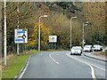
A370, Bridgwater Road
A relatively new section of the A370, bypassing the village of Uphill.
Image: © David Dixon
Taken: 10 Dec 2013
0.12 miles
10
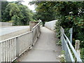
Pedestrian bridge alongside Oldmixon Bridge, Weston-super-Mare
Pedestrians use the metal bridge alongside the stone bridge. http://www.geograph.org.uk/photo/2653037
Image: © Jaggery
Taken: 27 Jul 2011
0.12 miles