IMAGES TAKEN NEAR TO
Canberra Road, WESTON-SUPER-MARE, BS23 4PN
Introduction
This page details the photographs taken nearby to Canberra Road, BS23 4PN by members of the Geograph project.
The Geograph project started in 2005 with the aim of publishing, organising and preserving representative images for every square kilometre of Great Britain, Ireland and the Isle of Man.

There are currently over 7.5m images from over14,400 individuals and you can help contribute to the project by visiting https://www.geograph.org.uk
Image Map
Images are licensed for reuse under creativecommons.org/licenses/by-sa/2.0
Notes
- Clicking on the map will re-center to the selected point.
- The higher the marker number, the further away the image location is from the centre of the postcode.
Image Listing (35 Images Found)
Images are licensed for reuse under creativecommons.org/licenses/by-sa/2.0
Image
Details
Distance
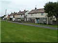
1
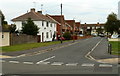
Hobart Road houses east of Canberra Road, Weston-super-Mare
Viewed across Canberra Road. Part of the Coronation Estate, where streets are named after cities in the British Commonwealth.
Image: © Jaggery
Taken: 27 Jul 2011
0.04 miles
3
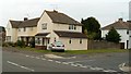
Corner of Canberra Road and Hobart Road, Weston-super-Mare
Part of the Coronation Estate.
Image: © Jaggery
Taken: 27 Jul 2011
0.06 miles
5
Windwhistle Lane houses, Weston-super-Mare
Part of the Coronation Estate. Behind the camera is this http://www.geograph.org.uk/photo/2715413 sculpture.
Image: © Jaggery
Taken: 27 Jul 2011
0.10 miles
6
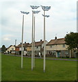
Fish on sticks sculpture, Windwhistle Lane, Weston-super-Mare
Designed by artist and sculptor David Kemp, five posts are each topped with a weather vane made of fish shapes. The sculpture is located near the corner of Windwhistle Lane and Canberra Road on the Coronation Estate.
This area was formerly under water. Rhynes (drainage ditches) http://www.geograph.org.uk/photo/2654577 help prevent flooding today but if global warming continues perhaps one day the sea will return. The sculpture is a reminder of the past and of a possible future...
Image: © Jaggery
Taken: 27 Jul 2011
0.10 miles
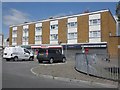
7
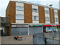
Windwhistle Post Office, Weston-super-Mare
Located at 7 Loxton Road, in a small row of shops. Its immediate neighbours are King's Barbers and a Spar store.
Image: © Jaggery
Taken: 27 Jul 2011
0.10 miles
8
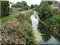
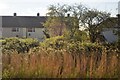
Cross Rhyne, Weston-super-Mare
A view west along the rhyne (drainage channel) from near Loxton Road.
Image: © Jaggery
Taken: 27 Jul 2011
0.11 miles
9
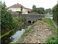
Cross Rhyne passes under Loxton Road, Weston-super-Mare
A rhyne (also spelt reen) is the local name for a drainage channel, a feature of low-lying coastal land on both sides of the Bristol Channel.
Image: © Jaggery
Taken: 27 Jul 2011
0.11 miles
10
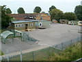
Windwhistle Primary School, Weston-super-Mare
Viewed from a railway footbridge. http://www.geograph.org.uk/photo/2715443
Image: © Jaggery
Taken: 27 Jul 2011
0.11 miles