1
Ordnance Survey Cut Mark
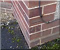
This OS cut mark can be found on No103 Totterdown Road. It marks a point 5.764m above mean sea level.
Image: © Adrian Dust
Taken: 9 Dec 2019
0.02 miles
2
Single Line Railway in Weston Super Mare
Here is a view from the footbridge where cycle route 33 crosses over the single loop line that serves Weston town centre, The housing on the right of the railway is all post war, while the housing on the left is all pre 1940's; in the distance Worlebury hill can be seen.
Image: © Ant Basterfield
Taken: 20 Feb 2010
0.07 miles
3
Ordnance Survey Cut Mark
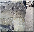
This OS cut mark can be found on the post of No34 Southville Road. It marks a point 5.907m above mean sea level.
Image: © Adrian Dust
Taken: 9 Dec 2019
0.11 miles
4
Addiscombe Road houses, Weston-super-Mare
Houses on the south side of the street viewed from the Devonshire Road end.
Image: © Jaggery
Taken: 27 Jul 2011
0.13 miles
5
Southville Road. W-S-M
A road full of work vans and cars.
Image: © John C
Taken: 25 Mar 2018
0.14 miles
6
Selbourne RD. W-S-M
Image: © John C
Taken: 25 Mar 2018
0.14 miles
7
Railway footbridge, Windwhistle Lane, Weston-super-Mare
The footbridge crosses above the single-track loop line that connects Weston-super-Mare railway station with the Bristol to Taunton line. A small blue sign on the lamppost shows that the footbridge is part of National Cycle Network route 33.
Image: © Jaggery
Taken: 27 Jul 2011
0.14 miles
8
Outdoor games court, Windwhistle Primary School, Weston-super-Mare
Viewed from a railway footbridge. http://www.geograph.org.uk/photo/2715443
Image: © Jaggery
Taken: 27 Jul 2011
0.14 miles
9
Windwhistle railway footbridge detail, Weston-super-Mare
The footbridge across a single-track railway line http://www.geograph.org.uk/photo/2715737 http://www.geograph.org.uk/photo/2715758 is only about 10 metres wide. Each of the double approach ramps on either side are 30 metres long, so crossing this single track requires the pedestrian to walk a distance of about 130 metres.
Image: © Jaggery
Taken: 27 Jul 2011
0.14 miles
10
Alexandra House, Weston-super-Mare
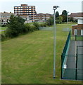
Viewed from a railway footbridge http://www.geograph.org.uk/photo/2715443 looking along Windwhistle Primary School grounds towards Alexandra House, a 7-storey block of flats in Lonsdale Avenue.
Image: © Jaggery
Taken: 27 Jul 2011
0.15 miles


