IMAGES TAKEN NEAR TO
Elmsleigh Road, WESTON-SUPER-MARE, BS23 4JN
Introduction
This page details the photographs taken nearby to Elmsleigh Road, BS23 4JN by members of the Geograph project.
The Geograph project started in 2005 with the aim of publishing, organising and preserving representative images for every square kilometre of Great Britain, Ireland and the Isle of Man.

There are currently over 7.5m images from over14,400 individuals and you can help contribute to the project by visiting https://www.geograph.org.uk
Image Map (Loading...)


Getting Data...Please wait
Leaflet Map data © OpenStreetMap
Images are licensed for reuse under creativecommons.org/licenses/by-sa/2.0
Notes
- Clicking on the map will re-center to the selected point.
- The higher the marker number, the further away the image location is from the centre of the postcode.
Image Listing (45 Images Found)
Images are licensed for reuse under creativecommons.org/licenses/by-sa/2.0
Image
Details
Distance
1
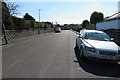
Delapre Road, W-S-M
Looking south along Delapre Road, from the Braen Down Road end.
Image: © John C
Taken: 25 Mar 2018
0.09 miles
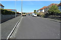
2

Woodland Road, Weston-Super-Mare
Looking N-NW from Brean Down Avenue.
Image: © John C
Taken: 25 Mar 2018
0.10 miles
3
Frenchay Road. W-S-M
Frenchay Road looking N-NE from Brean Down Rd.
Image: © John C
Taken: 25 Mar 2018
0.10 miles
5
Lyndhurst Road. W-S-M
Looking south along Lyndhurst Rd, from Moorland Road
Image: © John C
Taken: 25 Mar 2018
0.14 miles
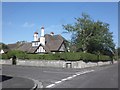
6
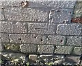
Ordnance Survey Cut Mark
This OS cut mark can be found on No78 Moorland Road. It marks a point 9.135m above mean sea level.
Image: © Adrian Dust
Taken: 9 Dec 2019
0.15 miles

9

Moorland Rd. chip shop and garages
These businesses are opposite the junction of Moorland Rd. and Lyndhurst Rd.
Image: © John C
Taken: 25 Mar 2018
0.16 miles
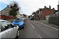
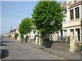
10
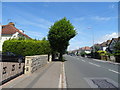
Devonshire Road, Weston-super-Mare
The A3033.
Image: © JThomas
Taken: 12 Jul 2019
0.16 miles