IMAGES TAKEN NEAR TO
Frenchay Road, WESTON-SUPER-MARE, BS23 4JL
Introduction
This page details the photographs taken nearby to Frenchay Road, BS23 4JL by members of the Geograph project.
The Geograph project started in 2005 with the aim of publishing, organising and preserving representative images for every square kilometre of Great Britain, Ireland and the Isle of Man.

There are currently over 7.5m images from over14,400 individuals and you can help contribute to the project by visiting https://www.geograph.org.uk
Image Map
Images are licensed for reuse under creativecommons.org/licenses/by-sa/2.0
Notes
- Clicking on the map will re-center to the selected point.
- The higher the marker number, the further away the image location is from the centre of the postcode.
Image Listing (43 Images Found)
Images are licensed for reuse under creativecommons.org/licenses/by-sa/2.0
Image
Details
Distance
1
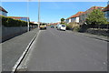
Frenchay Road. W-S-M
Frenchay Road looking N-NE from Brean Down Rd.
Image: © John C
Taken: 25 Mar 2018
0.05 miles
2
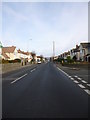
Devonshire Road, Weston-Super-Mare
Looking along Devonshire Road towards the town
Image: © John C
Taken: 22 Nov 2015
0.05 miles
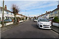
3
Devonshire Road, Weston-super-Mare
The A3033.
Image: © JThomas
Taken: 12 Jul 2019
0.06 miles

5
Houses on Devonshire Road, Weston-super-Mare
Image: © JThomas
Taken: 12 Jul 2019
0.08 miles
6
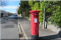
Brean Down Rd. and postbox
Post-box at the junction of Brean Down Rd and Devonshire Rd. W-S-M
Image: © John C
Taken: 25 Mar 2018
0.08 miles
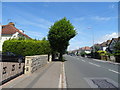
7
Addiscombe Rd. W-S-M
Looking eastwards along Addiscombe Rd.
Image: © John C
Taken: 25 Mar 2018
0.09 miles


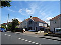
10
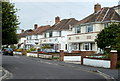
Addiscombe Road houses, Weston-super-Mare
Houses on the south side of the street viewed from the Devonshire Road end.
Image: © Jaggery
Taken: 27 Jul 2011
0.12 miles