IMAGES TAKEN NEAR TO
Moorland Road, WESTON-SUPER-MARE, BS23 4JA
Introduction
This page details the photographs taken nearby to Moorland Road, BS23 4JA by members of the Geograph project.
The Geograph project started in 2005 with the aim of publishing, organising and preserving representative images for every square kilometre of Great Britain, Ireland and the Isle of Man.

There are currently over 7.5m images from over14,400 individuals and you can help contribute to the project by visiting https://www.geograph.org.uk
Image Map (Loading...)


Getting Data...Please wait
Leaflet Map data © OpenStreetMap
Images are licensed for reuse under creativecommons.org/licenses/by-sa/2.0
Notes
- Clicking on the map will re-center to the selected point.
- The higher the marker number, the further away the image location is from the centre of the postcode.
Image Listing (53 Images Found)
Images are licensed for reuse under creativecommons.org/licenses/by-sa/2.0
Image
Details
Distance
1
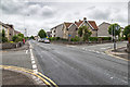
Junction on Drove Road
To the left, Whitting Road, to the right, Moorland Road.
Image: © David P Howard
Taken: 15 Jun 2016
0.02 miles
2
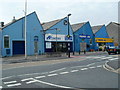
Former Moorland Laundry, Weston-super-Mare
The Devonshire Road building is divided into business units. In view are:
AP Cleaners offer a contract laundry service and also dry cleaning, repairs and alterations.
Proper Job is a DiY (Do it yourself) shop.
Image: © Jaggery
Taken: 27 Jul 2011
0.03 miles
3

Bus stop and post box together
Devonshire Road bus stop and post box, close to the junction of Moorland Road, (to the left) and Whitting Road, (to the right).
Image: © John C
Taken: 25 Mar 2018
0.03 miles
4

Whitting Rd. W-S-M
Whitting Rd off Devonshire Rd, Weston.
Image: © John C
Taken: 25 Mar 2018
0.05 miles
5

Bedford Road. W-S-M
Looking east from Devonshire Rd.
Image: © John C
Taken: 25 Mar 2018
0.06 miles
6
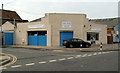
Weston Hospicecare shop, Weston-super-Mare
The charity shop is on the corner of Devonshire Road and Southend Road.
Weston Hospicecare is an independent charitable hospice, set up in 1989 with the purpose of providing free palliative care for people living with cancer, and other life-threatening conditions, in the Weston-super-Mare area. One source of income is from the sale here of items donated by the public.
Image: © Jaggery
Taken: 27 Jul 2011
0.06 miles
7
Tynings Mews. W-S-M
Tynings Mews is off Moorland Rd.
Many of the houses in this area have very large rear gardens. There are now a number of 'Mews' being developed to accommodate dwellings built in these back gardens.
Image: © John C
Taken: 25 Mar 2018
0.07 miles
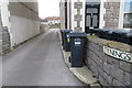
8
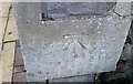
Ordnance Survey Cut Mark
This OS cut mark can be found on the gatepost of No147 Moorland Road. It marks a point 7.416m above mean sea level.
Image: © Adrian Dust
Taken: 9 Dec 2019
0.07 miles
9

Southend Rd. W-S-M
Looking west from Devonshire Rd.
Image: © John C
Taken: 25 Mar 2018
0.07 miles
10
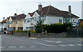
Quantock Road houses, Weston-super-Mare
Houses on the north side of Quantock Road between Exeter Road and Malvern Road.
Viewed across the A3033 from near the point where the A road to the south is Devonshire Road and Drove Road to the north.
Image: © Jaggery
Taken: 27 Jul 2011
0.07 miles