IMAGES TAKEN NEAR TO
Charlton Road, WESTON-SUPER-MARE, BS23 4HA
Introduction
This page details the photographs taken nearby to Charlton Road, BS23 4HA by members of the Geograph project.
The Geograph project started in 2005 with the aim of publishing, organising and preserving representative images for every square kilometre of Great Britain, Ireland and the Isle of Man.

There are currently over 7.5m images from over14,400 individuals and you can help contribute to the project by visiting https://www.geograph.org.uk
Image Map (Loading...)


Getting Data...Please wait
Leaflet Map data © OpenStreetMap
Images are licensed for reuse under creativecommons.org/licenses/by-sa/2.0
Notes
- Clicking on the map will re-center to the selected point.
- The higher the marker number, the further away the image location is from the centre of the postcode.
Image Listing (74 Images Found)
Images are licensed for reuse under creativecommons.org/licenses/by-sa/2.0
Image
Details
Distance
1
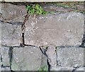
Ordnance Survey Cut Mark
This OS cut mark can be found on the wall of No2 Charlton Road. It marks a point 9.298m above mean sea level.
Image: © Adrian Dust
Taken: 9 Dec 2019
0.02 miles
2
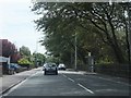
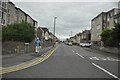
Uphill Road North
Uphill Road North passing a pair of bus stops near the golf course.
Image: © Ruth Riddle
Taken: 17 Jul 2012
0.05 miles
3
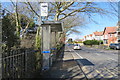
Bus stop - Uphill Rd. North
Bus stop situated in Uphill Road North, for buses into Weston town centre.
Image: © John C
Taken: 25 Mar 2018
0.05 miles
4
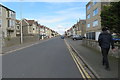
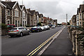
Moorland Road. W-S-M
Moorland Road at the Uphill Road North end.
Image: © John C
Taken: 25 Mar 2018
0.08 miles
5
Weston-Super-Mare : Moorland Road
Moorland Road seen from Uphill Road North.
Image: © Lewis Clarke
Taken: 20 Sep 2012
0.08 miles
6
Moorland Road, Weston-super-Mare
Looking WSW along Moorland Road.
Image: © David P Howard
Taken: 15 Jun 2016
0.08 miles
7
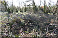
Scrub land 2
Scrub land with just a glimpse of the golf course beyond.
Image: © John C
Taken: 25 Mar 2018
0.09 miles
8
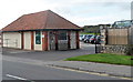
Golf Shop, Weston-super-Mare Golf Club
Located opposite the junction of the A370 Uphill Road North and Moorland Road
in Weston-super-Mare, the golf shop is open to the public.
Image: © Jaggery
Taken: 27 Sep 2012
0.09 miles
9
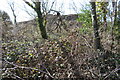
Scrub land
Scrub land between Uphill Rd. North and the golf course.
Image: © John C
Taken: 25 Mar 2018
0.09 miles
10
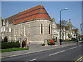
Chapel at Royal Court, Weston-Super-Mare
Royal Court was formerly The Sanatorium or Royal Hospital now converted to apartments.
Image: © don cload
Taken: 20 Apr 2011
0.11 miles