IMAGES TAKEN NEAR TO
Stradling Avenue, WESTON-SUPER-MARE, BS23 3RH
Introduction
This page details the photographs taken nearby to Stradling Avenue, BS23 3RH by members of the Geograph project.
The Geograph project started in 2005 with the aim of publishing, organising and preserving representative images for every square kilometre of Great Britain, Ireland and the Isle of Man.

There are currently over 7.5m images from over14,400 individuals and you can help contribute to the project by visiting https://www.geograph.org.uk
Image Map (Loading...)


Getting Data...Please wait
Leaflet Map data © OpenStreetMap
Images are licensed for reuse under creativecommons.org/licenses/by-sa/2.0
Notes
- Clicking on the map will re-center to the selected point.
- The higher the marker number, the further away the image location is from the centre of the postcode.
Image Listing (34 Images Found)
Images are licensed for reuse under creativecommons.org/licenses/by-sa/2.0
Image
Details
Distance
1
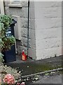
Ordnance Survey Cut Mark
This OS cut mark can be found on No 65 Stradling Avenue. It marks a point 5.712m above mean sea level.
Image: © Adrian Dust
Taken: 25 Sep 2023
0.09 miles
2
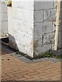
Ordnance Survey Cut Mark
This OS cut mark can be found on No 28 Stradling Avenue. It marks a point 5.749m above mean sea level.
Image: © Adrian Dust
Taken: 25 Sep 2023
0.11 miles
3
Bournville Road railway footbridge, Weston-super-Mare
Viewed from this bridge. http://www.geograph.org.uk/photo/3132486
The footbridge links Bournville Road with Dumfries Place.
There is a similar railway footbridge on the north side of the road bridge. http://www.geograph.org.uk/photo/3132533
Image: © Jaggery
Taken: 27 Jul 2011
0.12 miles
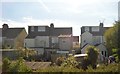
4
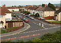
Stradling Avenue, Weston-super-Mare
Viewed from this http://www.geograph.org.uk/photo/3132486 bridge. Bournville Road is in the foreground.
Image: © Jaggery
Taken: 27 Jul 2011
0.12 miles
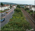
6
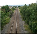
Line to Weston-super-Mare railway station
Viewed from Windwhistle Lane footbridge. http://www.geograph.org.uk/photo/2715443
The single track line is part of the loop connecting Weston-super-Mare station (out of shot nearly 2km ahead) with the Bristol to Taunton main line at Uphill Junction about 800 metres behind the camera.
Image: © Jaggery
Taken: 27 Jul 2011
0.14 miles
7
Ordnance Survey Cut Mark
This OS cut mark can be found on the wall of No1 Totterdown Road. It marks a point 5.803m above mean sea level.
Image: © Adrian Dust
Taken: 9 Dec 2019
0.14 miles
8
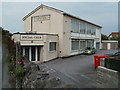
Weston-super-Mare Social Club
The club occupies a triangular site between Drove Road on the left, and railway lines.
Image: © Jaggery
Taken: 27 Jul 2011
0.14 miles
9
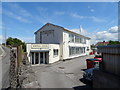
Weston-super-Mare Social Club
On Devonshire Road.
Image: © JThomas
Taken: 12 Jul 2019
0.15 miles
10
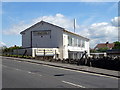
Weston-super-Mare Social Club
On Devonshire Road.
Image: © JThomas
Taken: 12 Jul 2019
0.16 miles