IMAGES TAKEN NEAR TO
Milton Road, WESTON-SUPER-MARE, BS23 2UN
Introduction
This page details the photographs taken nearby to Milton Road, BS23 2UN by members of the Geograph project.
The Geograph project started in 2005 with the aim of publishing, organising and preserving representative images for every square kilometre of Great Britain, Ireland and the Isle of Man.

There are currently over 7.5m images from over14,400 individuals and you can help contribute to the project by visiting https://www.geograph.org.uk
Image Map (55 Images)


Getting Data...Please wait
Leaflet Map data © OpenStreetMap
Images are licensed for reuse under creativecommons.org/licenses/by-sa/2.0
Notes
- Clicking on the map will re-center to the selected point.
- The higher the marker number, the further away the image location is from the centre of the postcode.
Image Listing (55 Images Found)
Images are licensed for reuse under creativecommons.org/licenses/by-sa/2.0
Image
Details
Distance
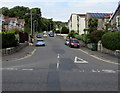
2
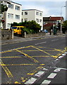
Yellow markings on Milton Road, Weston-super-Mare
The markings define the Keep Clear zone at the Milton Avenue junction.
Milton Avenue is the exit road from Weston-super-Mare Fire Station. https://www.geograph.org.uk/photo/5916451
Image: © Jaggery
Taken: 6 Sep 2018
0.02 miles
3
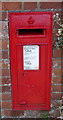
George V postbox on Milton Road, Weston-super-Mare
Postbox No. BS23 43.
See Image] for context.
Image: © JThomas
Taken: 12 Jul 2019
0.04 miles
4
Houses off Milton Road, Weston-super-Mare
Showing position of Postbox No. BS23 43.
See Image] for postbox.
Image: © JThomas
Taken: 12 Jul 2019
0.05 miles
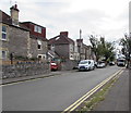
5
Up Manor Road, Weston-super-Mare
Manor Road ascends from the north side of Milton Road.
Image: © Jaggery
Taken: 6 Sep 2018
0.05 miles
6
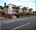
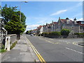
Semi-detached houses, Milton Road, Weston-super-Mare
On the north side of Milton Road between The Drive and Manor Road.
Image: © Jaggery
Taken: 6 Sep 2018
0.05 miles
7
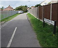
West along Colonel Stephens Way, Weston-super-Mare
The footpath/lane named Colonel Stephens Way follows the trackbed of the Weston, Clevedon & Portishead Light Railway (WC&PR), an independent light railway linking three North Somerset coastal towns. First planned in 1844, it opened in 1897 and closed in 1940.
Colonel Holman Fred Stephens took over the running of the WC&PR in 1911. He was known as the Light Railway King because he ran a number of similar railways, and he got the costs under control. He managed the railway mostly from his base in Tonbridge, Kent. After his death in 1931 the railway declined.
Image: © Jaggery
Taken: 6 Sep 2018
0.07 miles
8
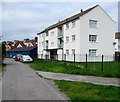
Blenheim Court, Weston-super-Mare
The Colonel Stephens Way side of flats on the south side of Milton Road.
Image: © Jaggery
Taken: 6 Sep 2018
0.08 miles
9
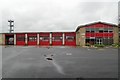
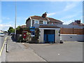
Weston-Super-Mare Fire Station
Weston-Super-Mare Fire Station, Milton Avenue, Weston-Super-Mare is station number 18 of Avon Fire & Rescue Service
Image: © Kevin Hale
Taken: 8 May 2006
0.08 miles
10
Milton Avenue, Weston-super-Mare
From Milton Road along Milton Avenue towards Weston-super-Mare Fire Station. https://www.geograph.org.uk/photo/5916451
Image: © Jaggery
Taken: 6 Sep 2018
0.08 miles