IMAGES TAKEN NEAR TO
Milton Road, WESTON-SUPER-MARE, BS23 2SN
Introduction
This page details the photographs taken nearby to Milton Road, BS23 2SN by members of the Geograph project.
The Geograph project started in 2005 with the aim of publishing, organising and preserving representative images for every square kilometre of Great Britain, Ireland and the Isle of Man.

There are currently over 7.5m images from over14,400 individuals and you can help contribute to the project by visiting https://www.geograph.org.uk
Image Map (100 Images)


Leaflet Map data © OpenStreetMap
Images are licensed for reuse under creativecommons.org/licenses/by-sa/2.0
Notes
- Clicking on the map will re-center to the selected point.
- The higher the marker number, the further away the image location is from the centre of the postcode.
Image Listing (100 Images Found)
Images are licensed for reuse under creativecommons.org/licenses/by-sa/2.0
Image
Details
Distance
1
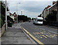
Milton Road bus stop, Weston-super-Mare
In September 2018 this is a stop on First bus route 7 from Oldmixon to Worle via Weston-super-Mare town centre.
Image: © Jaggery
Taken: 6 Sep 2018
0.02 miles
2
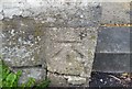
Ordnance Survey Cut Mark
This OS cut mark can be found on the gatepost of No48 Milton Road. It marks a point 5.633m above mean sea level.
Image: © Adrian Dust
Taken: 30 Jul 2018
0.02 miles
3
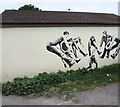
Leapers mural, Colonel Stephens Way, Weston-super-Mare
For want of a better word, I've described this mural as depicting leapers.
Is it perhaps some kind of modern energetic dance for young people?
Update. My daughter told me "It appears to be a move I've seen in a few movies where the person in the middle is a superhero or very powerful and they can make a group of people fly back in the air by one movement."
That explanation appears plausible and explains why one person is not in the air.
Image: © Jaggery
Taken: 6 Sep 2018
0.04 miles
4
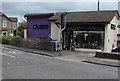
Vanda Flowers, 42A Milton Road, Weston-super-Mare
Opposite the entrance to Milton Road Cemetery.
Image: © Jaggery
Taken: 6 Sep 2018
0.04 miles
5
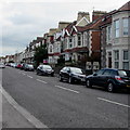
Cars and houses, Milton Road, Weston-super-Mare
Image: © Jaggery
Taken: 6 Sep 2018
0.04 miles
6
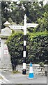
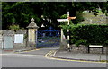
Direction Sign - Signpost by Milton Road, Weston Super Mare
Pyramid finial - 2 arms; Somerset pointing fingers by the UC road, in parish of Weston Super Mare (North Somerset District), Milton Road junction with Ashcombe Road, close to cemetery gates, by stone wall, North side of road. See https://www.geograph.org.uk/photo/7627807 for a more recent photo.
Surveyed
Milestone Society National ID: SO_ST3261
Image: © R Raynsford
Taken: 1 Apr 2013
0.04 miles
7
Direction Sign - Signpost by Milton Road, Weston super Mare
Located beside the cemetery gates on the north side of the Junction of Milton Road and Ashcombe Road in Weston super Mare parish. 2 arms and pyramid finial. Weston-super-Mare Town Council has started a project to repaint fingerposts in the area. See also https://www.geograph.org.uk/photo/6098916 for an older photo.
Milestone Society National ID: SO_ST3261
Image: © M Davis
Taken: 1 Oct 2023
0.04 miles
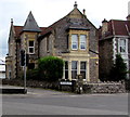
8
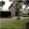
Former Milton Road Cemetery Lodge, Weston-super-Mare
The former lodge at the Milton Road entrance to the cemetery is now in residential use.
Image: © Jaggery
Taken: 6 Sep 2018
0.05 miles
9
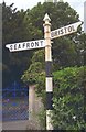
Old-style signpost, Milton Road, Weston-super-Mare
Pointing the way to Bristol and to Weston-super-Mare seafront, the signpost is near the southern entrance to Milton Road Cemetery.
Image: © Jaggery
Taken: 6 Sep 2018
0.05 miles
10
Corner of Ashcombe Road and Colonel Stephens Way, Weston-super-Mare
The name sign shows that the footpath/lane named Colonel Stephens Way follows the trackbed of the Weston, Clevedon & Portishead Light Railway (WC&PR), an independent light railway linking three North Somerset coastal towns. First planned in 1844, it opened in 1897 and closed in 1940.
Colonel Holman Fred Stephens took over the running of the WC&PR in 1911. He was known as the Light Railway King because he ran a number of similar railways, and he got the costs under control. He managed the railway mostly from his base in Tonbridge, Kent. After his death in 1931 the railway declined.
Image: © Jaggery
Taken: 6 Sep 2018
0.05 miles