IMAGES TAKEN NEAR TO
Trewartha Close, WESTON-SUPER-MARE, BS23 2RU
Introduction
This page details the photographs taken nearby to Trewartha Close, BS23 2RU by members of the Geograph project.
The Geograph project started in 2005 with the aim of publishing, organising and preserving representative images for every square kilometre of Great Britain, Ireland and the Isle of Man.

There are currently over 7.5m images from over14,400 individuals and you can help contribute to the project by visiting https://www.geograph.org.uk
Image Map (Loading...)


Getting Data...Please wait
Leaflet Map data © OpenStreetMap
Images are licensed for reuse under creativecommons.org/licenses/by-sa/2.0
Notes
- Clicking on the map will re-center to the selected point.
- The higher the marker number, the further away the image location is from the centre of the postcode.
Image Listing (130 Images Found)
Images are licensed for reuse under creativecommons.org/licenses/by-sa/2.0
Image
Details
Distance
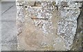
1
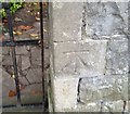
Ordnance Survey Cut Mark
This OS cut mark can be found on the gatepost of Beaufort Lodge. It marks a point 18.328m above mean sea level.
Image: © Adrian Dust
Taken: 30 Jul 2018
0.05 miles
2
Ordnance Survey Cut Mark
This OS cut mark can be found on the gatepost of The Brow, No35 Trewartha Park. It marks a point 27.328m above mean sea level.
Image: © Adrian Dust
Taken: 30 Jul 2018
0.05 miles
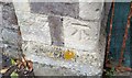
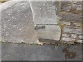
4
Ordnance Survey Cut Mark
This inverted OS cut mark can be found on the gatepost of No37 Hill Road. It marks a point 9.589m above mean sea level.
Image: © Adrian Dust
Taken: 30 Jul 2018
0.08 miles
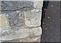
5

Ordnance Survey Cut Mark
This OS cut mark can be found on a wall east side of the path in Milton Road Cemetery. It marks a point 28.325m above mean sea level.
Image: © Adrian Dust
Taken: 30 Jul 2018
0.09 miles
6
Ordnance Survey Cut Mark
This OS cut mark can be found on the gatepost of No18 Trewartha Park. It marks a point 36.262m above mean sea level.
Image: © Adrian Dust
Taken: 30 Jul 2018
0.09 miles
7
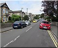
North along Hill Road, Weston-super-Mare
From Milton Road along Hill Road towards Trewartha Park.
Image: © Jaggery
Taken: 6 Sep 2018
0.10 miles
8

New grounds
Milton Road cemetery was extended in the 1930s, taking in part of the Ashcombe House estate. The hillside slope gives a good impression of the scale of the new grounds.
Image: © Neil Owen
Taken: 10 Jun 2013
0.10 miles
9
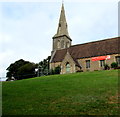
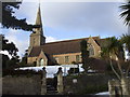
Grade II listed Christ Church, Montpelier, Weston-super-Mare
Christ Church is part of the Church of England Diocese of Bath & Wells.
Built in 1854-1855, enlarged in 1878, Grade II listed in 1983.
Image: © Jaggery
Taken: 6 Sep 2018
0.10 miles
10
Ordnance Survey Cut Mark
This OS cut mark can be found on the gatepost of No7 Montpelier.. It marks a point 81.23ft above mean sea level.
Image: © Adrian Dust
Taken: 28 Jul 2023
0.10 miles