IMAGES TAKEN NEAR TO
Montpelier, WESTON-SUPER-MARE, BS23 2RQ
Introduction
This page details the photographs taken nearby to Montpelier, BS23 2RQ by members of the Geograph project.
The Geograph project started in 2005 with the aim of publishing, organising and preserving representative images for every square kilometre of Great Britain, Ireland and the Isle of Man.

There are currently over 7.5m images from over14,400 individuals and you can help contribute to the project by visiting https://www.geograph.org.uk
Image Map (Loading...)


Getting Data...Please wait
Leaflet Map data © OpenStreetMap
Images are licensed for reuse under creativecommons.org/licenses/by-sa/2.0
Notes
- Clicking on the map will re-center to the selected point.
- The higher the marker number, the further away the image location is from the centre of the postcode.
Image Listing (142 Images Found)
Images are licensed for reuse under creativecommons.org/licenses/by-sa/2.0
Image
Details
Distance
1
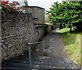
Christ Church Path North, Weston-super-Mare
Opposite Christ Church https://www.geograph.org.uk/photo/5902438 the path descends from Montpelier towards Gerard Road.
Image: © Jaggery
Taken: 6 Sep 2018
0.00 miles
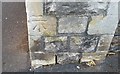
2
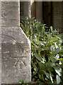
Christ Church benchmark
A cutmark, somewhat softened by the weathering, on the foot of the spire. See Image] for a look up to the heavens, and http://www.bench-marks.org.uk/bm39532 for the entry in the Benchmark Database.
Image: © Neil Owen
Taken: 27 Sep 2012
0.01 miles
3
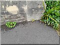
Ordnance Survey Cut Mark
This OS cut mark can be found on the SW angle of Christ Church. It marks a point 19.068m above mean sea level.
Image: © Adrian Dust
Taken: 28 Jul 2023
0.01 miles
4
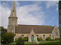
Christ Church, Montpelier
Church's southerly aspect, with its spire easily visible from most parts of Weston. See Image] for a benchmark on the bottom of the spire.
Image: © Neil Owen
Taken: 27 Sep 2012
0.02 miles
5
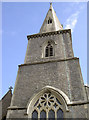
Christ Church spire
Occupying a prominent position on the steep hillside away from the seafront, the church can be seen for several miles. See Image] for a wider view.
Image: © Neil Owen
Taken: 27 Sep 2012
0.02 miles
6
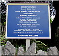
Christ Church information board, Montpelier, Weston-super-Mare
Facing the road named Montpelier at the main entrance to this https://www.geograph.org.uk/photo/5902438 church, viewed on September 6th 2018.
Image: © Jaggery
Taken: 6 Sep 2018
0.02 miles
7
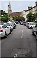
Up Montpelier towards Christ Church, Weston-super-Mare
The road named Montpelier ascends from Milton Road towards Christ Church. https://www.geograph.org.uk/photo/5902438
Image: © Jaggery
Taken: 6 Sep 2018
0.02 miles
8
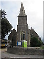
West side of Christ Church, Weston-super-Mare
Church tower and steeple viewed across the road named Montpelier.
Christ Church is part of the Church of England Diocese of Bath & Wells.
Built in 1854-1855, enlarged in 1878, Grade II listed in 1983.
https://www.geograph.org.uk/photo/5902438 to a broader view.
Image: © Jaggery
Taken: 6 Sep 2018
0.02 miles
9
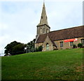
Grade II listed Christ Church, Montpelier, Weston-super-Mare
Christ Church is part of the Church of England Diocese of Bath & Wells.
Built in 1854-1855, enlarged in 1878, Grade II listed in 1983.
Image: © Jaggery
Taken: 6 Sep 2018
0.03 miles
10
Ordnance Survey Cut Mark
This OS cut mark can be found on the gatepost SW side of Montpelier. It marks a point 11.820m above mean sea level.
Image: © Adrian Dust
Taken: 30 Jul 2018
0.04 miles