IMAGES TAKEN NEAR TO
Trewartha Park, WESTON-SUPER-MARE, BS23 2RP
Introduction
This page details the photographs taken nearby to Trewartha Park, BS23 2RP by members of the Geograph project.
The Geograph project started in 2005 with the aim of publishing, organising and preserving representative images for every square kilometre of Great Britain, Ireland and the Isle of Man.

There are currently over 7.5m images from over14,400 individuals and you can help contribute to the project by visiting https://www.geograph.org.uk
Image Map (Loading...)


Getting Data...Please wait
Leaflet Map data © OpenStreetMap
Images are licensed for reuse under creativecommons.org/licenses/by-sa/2.0
Notes
- Clicking on the map will re-center to the selected point.
- The higher the marker number, the further away the image location is from the centre of the postcode.
Image Listing (75 Images Found)
Images are licensed for reuse under creativecommons.org/licenses/by-sa/2.0
Image
Details
Distance
1
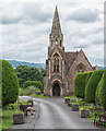
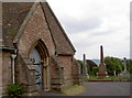
Chapel in Milton Road Cemetery
View south from Bristol Road Lower.
Image: © David P Howard
Taken: 15 Jun 2016
0.05 miles
2
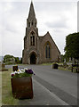
Cemetery chapel
Milton Road cemetery used to have two chapels, all but adjoining each other. One was for Church of England and the other for non-Conformist services but the latter was demolished in 1980.
See Image] for a benchmark on the far side, or Image] for a side view.
Image: © Neil Owen
Taken: 10 Jun 2013
0.05 miles
3
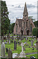
Chapel in the cemetery
View SSW from Bristol Road Lower, across Milton Road Cemetery.
Image: © David P Howard
Taken: 15 Jun 2016
0.05 miles
4
Airy chapel
The small chapel in Milton Road cemetery, allowing plenty of fresh air through the spire. See Image] for a different view.
Image: © Neil Owen
Taken: 10 Jun 2013
0.05 miles
5
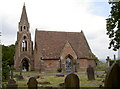
The only chapel left in the cemetery
This is the Church of England chapel in Milton Road cemetery. Originally it had a Non-Conformist chapel for company but that was removed in 1980.
See Image] for a benchmark at the far end of the wall.
Image: © Neil Owen
Taken: 10 Jun 2013
0.05 miles
6
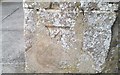
Chapel mark
A cutmark, as listed in the Benchmark Database: http://www.bench-marks.org.uk/bm49694 , on the chapel in the middle of Milton Road cemetery. See Image] for a look at the surviving chapel and a look from up the road.
Image: © Neil Owen
Taken: 10 Jun 2013
0.05 miles
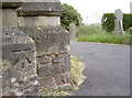
7
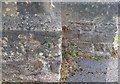
Ordnance Survey Cut Mark
This OS cut mark can be found on the west face of Milton Road Cemetery Chapel. It marks a point 39.536m above mean sea level.
Image: © Adrian Dust
Taken: 30 Jul 2018
0.05 miles
8
Ordnance Survey Cut Mark
This OS cut mark can be found on the gatepost of No18 Trewartha Park. It marks a point 36.262m above mean sea level.
Image: © Adrian Dust
Taken: 30 Jul 2018
0.05 miles
9

Bristol Road Lower
From its junction with Arundel Road with Eastfield Park on the left.
Image: © Bob Embleton
Taken: 5 Mar 2012
0.05 miles
10
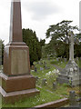
Gravestones in Milton Road cemetery
The fairly modern layout of the cemetery blends a variety of trees and plants with some interesting memorials.
Image: © Neil Owen
Taken: 10 Jun 2013
0.06 miles