IMAGES TAKEN NEAR TO
Grove Park Road, WESTON-SUPER-MARE, BS23 2LN
Introduction
This page details the photographs taken nearby to Grove Park Road, BS23 2LN by members of the Geograph project.
The Geograph project started in 2005 with the aim of publishing, organising and preserving representative images for every square kilometre of Great Britain, Ireland and the Isle of Man.

There are currently over 7.5m images from over14,400 individuals and you can help contribute to the project by visiting https://www.geograph.org.uk
Image Map (Loading...)


Getting Data...Please wait
Leaflet Map data © OpenStreetMap
Images are licensed for reuse under creativecommons.org/licenses/by-sa/2.0
Notes
- Clicking on the map will re-center to the selected point.
- The higher the marker number, the further away the image location is from the centre of the postcode.
Image Listing (122 Images Found)
Images are licensed for reuse under creativecommons.org/licenses/by-sa/2.0
Image
Details
Distance
1
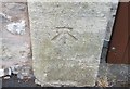
Ordnance Survey Cut Mark
This OS cut mark can be found on the gatepost of No21 Queens Road. It marks a point 42.389m above mean sea level.
Image: © Adrian Dust
Taken: 30 Jul 2018
0.02 miles
2
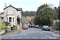
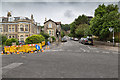
Queen's Road
From its junction with Upper Church Road.
The Town Quarry can be seen straight ahead.
Image: © Bob Embleton
Taken: 5 Mar 2012
0.03 miles
3

Weston-super-Mare from Worlebury Hill
View southwards along the Weston beach. The pier is just visible through the trees to the right.
Image: © Trevor Rickard
Taken: Unknown
0.05 miles

5
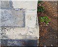
Ordnance Survey Cut Mark
This OS cut mark can be found on the gatepost of Manor Mead at the junction of Queens Road & Cecil Road. It marks a point 49.353m above mean sea level.
Image: © Adrian Dust
Taken: 30 Jul 2018
0.05 miles
6
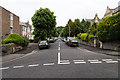
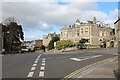
Grove Park Road
View north up Grove Park Road from the junction with Upper Church Road.
Image: © David P Howard
Taken: 15 Jun 2016
0.06 miles
7
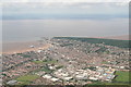
Weston Super Mare and Worlebury Hill: aerial 2020 (1)
Image: © Simon Tomson
Taken: 19 Jul 2020
0.06 miles
8
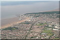
Weston Super Mare and Worlebury Hill: aerial 2020 (2)
Image: © Simon Tomson
Taken: 19 Jul 2020
0.06 miles
9
Queen's Road, Weston-super-Mare
Looking north up Queen's Road.
Image: © David P Howard
Taken: 15 Jun 2016
0.08 miles
10
Upper Church Road
From its junction with Queen's Road.
Image: © Bob Embleton
Taken: 5 Mar 2012
0.08 miles