IMAGES TAKEN NEAR TO
Shrubbery Avenue, WESTON-SUPER-MARE, BS23 2JW
Introduction
This page details the photographs taken nearby to Shrubbery Avenue, BS23 2JW by members of the Geograph project.
The Geograph project started in 2005 with the aim of publishing, organising and preserving representative images for every square kilometre of Great Britain, Ireland and the Isle of Man.

There are currently over 7.5m images from over14,400 individuals and you can help contribute to the project by visiting https://www.geograph.org.uk
Image Map (Loading...)


Getting Data...Please wait
Leaflet Map data © OpenStreetMap
Images are licensed for reuse under creativecommons.org/licenses/by-sa/2.0
Notes
- Clicking on the map will re-center to the selected point.
- The higher the marker number, the further away the image location is from the centre of the postcode.
Image Listing (111 Images Found)
Images are licensed for reuse under creativecommons.org/licenses/by-sa/2.0
Image
Details
Distance
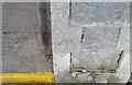
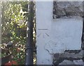
1
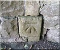
Ordnance Survey Cut Mark
This OS cut mark can be found on the wall post NE side of Shrubbery Terrace. It marks a point 39.722m above mean sea level.
Image: © Adrian Dust
Taken: 6 Jul 2019
0.06 miles
2
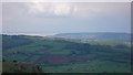
Distant view of Weston-Super-Mare from Crook Peak, Somerset
Green fields cover the north eastern slopes of Bleadon Hill in the foreground. Traffic can be seen on the M5 motorway which runs through the valley between Crook Hill and Bleadon Hill.
Image: © Anthony O'Neil
Taken: 12 May 2010
0.06 miles
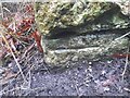
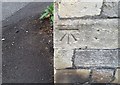
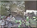
3
Ordnance Survey Cut Mark
This OS cut mark can be found on the gatepost of No24 Highbury Road. It marks a point 34.503m above mean sea level.
Image: © Adrian Dust
Taken: 30 Jul 2018
0.07 miles
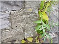
4
Ordnance Survey Cut Mark
This OS cut mark can be found on wall south side of the woodland path. It marks a point 73.429m above mean sea level.
Image: © Adrian Dust
Taken: 23 Dec 2022
0.07 miles
5
Ordnance Survey Cut Mark
This OS cut mark can be found on the wall post of No27 Atlantic Road. It marks a point 42.825m above mean sea level.
Image: © Adrian Dust
Taken: 30 Jul 2018
0.07 miles
6
Ordnance Survey Cut Mark
This OS cut mark can be found on the gatepost of No47 South Road. It marks a point 54.099m above mean sea level.
Image: © Adrian Dust
Taken: 30 Jul 2018
0.07 miles
7
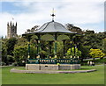
The Bandstand, Grove Park, Weston-super-Mare
Image: © PAUL FARMER
Taken: 17 Sep 2015
0.08 miles
8
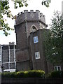
Water Tower Villa Rosa estate Weston-super-Mare
Image: © Hazel Stanmore-Richards
Taken: 8 Sep 2010
0.08 miles
9
Ordnance Survey Cut Mark
This OS cut mark can be found on No16 Shrubbery Avenue. It marks a point 44.056m above mean sea level.
Image: © Adrian Dust
Taken: 6 Jul 2019
0.08 miles
10
Ordnance Survey Cut Mark
This OS cut mark can be found on wall south side of the woodland path. It marks a point 79.900m above mean sea level.
Image: © Adrian Dust
Taken: 23 Dec 2022
0.08 miles