IMAGES TAKEN NEAR TO
Trinity Road, WESTON-SUPER-MARE, BS23 2HP
Introduction
This page details the photographs taken nearby to Trinity Road, BS23 2HP by members of the Geograph project.
The Geograph project started in 2005 with the aim of publishing, organising and preserving representative images for every square kilometre of Great Britain, Ireland and the Isle of Man.

There are currently over 7.5m images from over14,400 individuals and you can help contribute to the project by visiting https://www.geograph.org.uk
Image Map
Images are licensed for reuse under creativecommons.org/licenses/by-sa/2.0
Notes
- Clicking on the map will re-center to the selected point.
- The higher the marker number, the further away the image location is from the centre of the postcode.
Image Listing (223 Images Found)
Images are licensed for reuse under creativecommons.org/licenses/by-sa/2.0
Image
Details
Distance
1
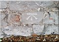
Ordnance Survey Cut Mark
This OS cut mark can be found on the wall NW side of Trinity Road. It marks a point 53.465m above mean sea level.
Image: © Adrian Dust
Taken: 30 Jul 2018
0.01 miles
2
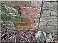
Ordnance Survey Cut Mark
This OS cut mark can be found on wall SE side of the woodland path. It marks a point 60.070m above mean sea level.
Image: © Adrian Dust
Taken: 23 Dec 2022
0.03 miles
3
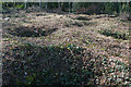
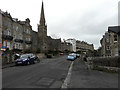
Weston-super-Mare: Worlebury hillfort
Recent tree clearance of part of the 10-acre site, in the hands of North Somerset Council, has revealed some of the 93 storage pits first discovered in the 1850s, when the site was excavated by a group of antiquarians. Grain was found in a number of the pits, which are unusually large at 6 to 8 feet in diameter and typically 6 feet deep. For a good guide to the hillfort, see ‘Worlebury. The story of the Iron Age hill-fort at Weston-super-Mare’, obtainable from Woodspring Museum, Burlington Street, Weston-super-Mare BS23 1PR. Phone 01934 612006
Image: © Martin Bodman
Taken: 9 Mar 2006
0.03 miles
4
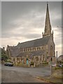
Holy Trinity Church, South Road
The church is a Grade II* Listed Building (English Heritage ID:33233 http://www.britishlistedbuildings.co.uk/en-33233-holy-trinity-church-weston-super-mare- British Listed Buildings). It dates from 1861.
Image: © David Dixon
Taken: 12 Dec 2013
0.05 miles
5
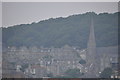
Weston-Super-Mare : Church & Coastal Town
Looking up towards the church and houses which overlook Weston Super Mare.
Image: © Lewis Clarke
Taken: 29 Jul 2011
0.06 miles
6
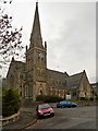
Holy Trinity Church, Weston-Super-Mare
Holy Trinity Church is a Grade II* Listed Building (English Heritage ID:33233 http://www.britishlistedbuildings.co.uk/en-33233-holy-trinity-church-weston-super-mare- British Listed Buildings). It dates from 1861.
Image: © David Dixon
Taken: 12 Dec 2013
0.06 miles
7
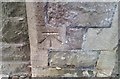
Ordnance Survey Cut Mark
This OS cut mark can be found on the wall of Holy Trinity Church, South Road. It marks a point 43.827m above mean sea level.
Image: © Adrian Dust
Taken: 30 Jul 2018
0.06 miles
8
Holy Trinity Church, Atlantic Road
It is a grade II listed building that was built in 1861 by H Lloyd http://www.britishlistedbuildings.co.uk/en-33233-holy-trinity-church-weston-super-mare-#.Vzy1_sv2bcc
Image: © John Baker
Taken: 7 Apr 2016
0.07 miles
9
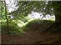
Entrance to another world
An Iron Age world! Worlebury has a long history and a quite unusual one - the remains date back to around 300B.C. and the occupation by members of what the Romans called the Dobunni. They built a rather elaborate hill top fort and this is one of the entrances. They also built some impressive stone walls that were about 10m (35ft) thick at the base and some 8m (27ft) tall.
Image: © Neil Owen
Taken: 10 Jun 2013
0.07 miles
10
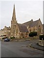
Weston-Super-Mare, Holy Trinity Church
The church is a Grade II* Listed Building (English Heritage ID:33233 http://www.britishlistedbuildings.co.uk/en-33233-holy-trinity-church-weston-super-mare- British Listed Buildings). It dates from 1861.
Image: © David Dixon
Taken: 12 Dec 2013
0.07 miles