IMAGES TAKEN NEAR TO
South Road, WESTON-SUPER-MARE, BS23 2HF
Introduction
This page details the photographs taken nearby to South Road, BS23 2HF by members of the Geograph project.
The Geograph project started in 2005 with the aim of publishing, organising and preserving representative images for every square kilometre of Great Britain, Ireland and the Isle of Man.

There are currently over 7.5m images from over14,400 individuals and you can help contribute to the project by visiting https://www.geograph.org.uk
Image Map (Loading...)


Getting Data...Please wait
Leaflet Map data © OpenStreetMap
Images are licensed for reuse under creativecommons.org/licenses/by-sa/2.0
Notes
- Clicking on the map will re-center to the selected point.
- The higher the marker number, the further away the image location is from the centre of the postcode.
Image Listing (262 Images Found)
Images are licensed for reuse under creativecommons.org/licenses/by-sa/2.0
Image
Details
Distance
1
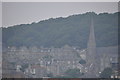
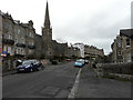
Weston-Super-Mare : Church & Coastal Town
Looking up towards the church and houses which overlook Weston Super Mare.
Image: © Lewis Clarke
Taken: 29 Jul 2011
0.04 miles
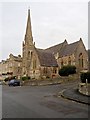
2
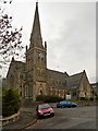
Holy Trinity Church, Weston-Super-Mare
Holy Trinity Church is a Grade II* Listed Building (English Heritage ID:33233 http://www.britishlistedbuildings.co.uk/en-33233-holy-trinity-church-weston-super-mare- British Listed Buildings). It dates from 1861.
Image: © David Dixon
Taken: 12 Dec 2013
0.04 miles
3
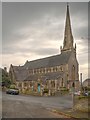
Holy Trinity Church, South Road
The church is a Grade II* Listed Building (English Heritage ID:33233 http://www.britishlistedbuildings.co.uk/en-33233-holy-trinity-church-weston-super-mare- British Listed Buildings). It dates from 1861.
Image: © David Dixon
Taken: 12 Dec 2013
0.04 miles
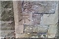
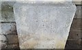
4
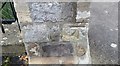
Ordnance Survey Cut Mark
This OS cut mark can be found on the wall post of No12 Atlantic Road. It marks a point 38.807m above mean sea level.
Image: © Adrian Dust
Taken: 30 Jul 2018
0.05 miles
5
Holy Trinity Church, Atlantic Road
It is a grade II listed building that was built in 1861 by H Lloyd http://www.britishlistedbuildings.co.uk/en-33233-holy-trinity-church-weston-super-mare-#.Vzy1_sv2bcc
Image: © John Baker
Taken: 7 Apr 2016
0.05 miles
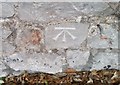
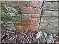
6
Ordnance Survey Cut Mark
This OS cut mark can be found on the wall of Holy Trinity Church, South Road. It marks a point 43.827m above mean sea level.
Image: © Adrian Dust
Taken: 30 Jul 2018
0.05 miles
7
Ordnance Survey Cut Mark
This OS cut mark can be found on the wall NW side of Trinity Road. It marks a point 53.465m above mean sea level.
Image: © Adrian Dust
Taken: 30 Jul 2018
0.05 miles
8
Weston-Super-Mare, Holy Trinity Church
The church is a Grade II* Listed Building (English Heritage ID:33233 http://www.britishlistedbuildings.co.uk/en-33233-holy-trinity-church-weston-super-mare- British Listed Buildings). It dates from 1861.
Image: © David Dixon
Taken: 12 Dec 2013
0.06 miles
9
Ordnance Survey Cut Mark
This OS cut mark can be found on the wall post north side of South Road. It marks a point 109.88ft above mean sea level.
Image: © Adrian Dust
Taken: 30 Jul 2018
0.06 miles
10
Ordnance Survey Cut Mark
This OS cut mark can be found on wall SE side of the woodland path. It marks a point 60.070m above mean sea level.
Image: © Adrian Dust
Taken: 23 Dec 2022
0.06 miles