IMAGES TAKEN NEAR TO
Madeira Road, WESTON-SUPER-MARE, BS23 2EL
Introduction
This page details the photographs taken nearby to Madeira Road, BS23 2EL by members of the Geograph project.
The Geograph project started in 2005 with the aim of publishing, organising and preserving representative images for every square kilometre of Great Britain, Ireland and the Isle of Man.

There are currently over 7.5m images from over14,400 individuals and you can help contribute to the project by visiting https://www.geograph.org.uk
Image Map
Images are licensed for reuse under creativecommons.org/licenses/by-sa/2.0
Notes
- Clicking on the map will re-center to the selected point.
- The higher the marker number, the further away the image location is from the centre of the postcode.
Image Listing (268 Images Found)
Images are licensed for reuse under creativecommons.org/licenses/by-sa/2.0
Image
Details
Distance
1
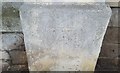
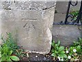
Ordnance Survey Cut Mark
This OS cut mark can be found on the wall post north side of South Road. It marks a point 109.88ft above mean sea level.
Image: © Adrian Dust
Taken: 30 Jul 2018
0.02 miles
2
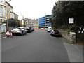
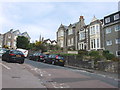
Looking east-southeast along South Road
Scaffolding and blue safety netting covers the exterior of The Dorville Hotel, which is located at 18, Madeira Road. The ongoing building work is described in North Somerset Council’s planning application 12/P/2268/F as the “conversion of existing hotel and annexe to form 20 one and two bedroom flats with associated vehicular parking, bin and cycle storage”. In the distance is the spire of Image
Image: © John Baker
Taken: 7 Apr 2016
0.03 miles
3
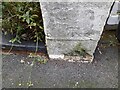
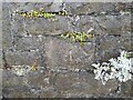
Ordnance Survey Cut Mark
This OS cut mark can be found on the gatepost of No11 Upper Kewstoke Road. It marks a point 24.994m above mean sea level.
Image: © Adrian Dust
Taken: 23 Dec 2022
0.06 miles
5
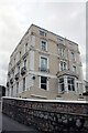
Addington Court, 2 and 4 Madeira Road, Weston-Super-Mare
Now flats, it was previously Addington Hotel the home of young Alfred Leete (1882-1933) famous for the Lord Kitchener 'Your Country Needs You' poster that hit the magazine stalls on September 5th 1915. A blue plaque, paid for by Weston Town Council, was unveiled on the building on Friday 22nd June 2018 to coincide with Armed Forces Weekend.
Image: © Jo and Steve Turner
Taken: 10 Mar 2022
0.06 miles
6
Ordnance Survey Cut Mark
This OS cut mark can be found on wall at the junction of Upper Kewstoke Road & South Road. It marks a point 29.057m above mean sea level.
Image: © Adrian Dust
Taken: 23 Dec 2022
0.06 miles
7
Ordnance Survey Cut Mark
This OS cut mark can be found on the gatepost NE side of the road. It marks a point 36.280m above mean sea level.
Image: © Adrian Dust
Taken: 30 Jul 2018
0.07 miles
8
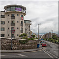
Birnbeck Road, Weston-super-Mare
The week before the EU referendum. A large poster declaring "We want our country back" is displayed at the top of an apartment block.
Image: © David P Howard
Taken: 15 Jun 2016
0.07 miles
10
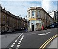
Hayers Premier store in Weston-super-Mare
Convenience store at 48 Birnbeck Road.
Image: © Jaggery
Taken: 27 Sep 2012
0.08 miles