IMAGES TAKEN NEAR TO
Manilla Crescent, WESTON-SUPER-MARE, BS23 2BW
Introduction
This page details the photographs taken nearby to Manilla Crescent, BS23 2BW by members of the Geograph project.
The Geograph project started in 2005 with the aim of publishing, organising and preserving representative images for every square kilometre of Great Britain, Ireland and the Isle of Man.

There are currently over 7.5m images from over14,400 individuals and you can help contribute to the project by visiting https://www.geograph.org.uk
Image Map (Loading...)


Getting Data...Please wait
Leaflet Map data © OpenStreetMap
Images are licensed for reuse under creativecommons.org/licenses/by-sa/2.0
Notes
- Clicking on the map will re-center to the selected point.
- The higher the marker number, the further away the image location is from the centre of the postcode.
Image Listing (323 Images Found)
Images are licensed for reuse under creativecommons.org/licenses/by-sa/2.0
Image
Details
Distance
1
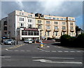
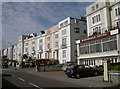
Birchfield Hotel, Weston-super-Mare
On the corner of Manilla Crescent and Manilla Place.
Image: © Jaggery
Taken: 27 Sep 2012
0.01 miles
2
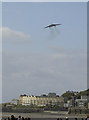
Wheels down over Worle
The famous Vulcan bomber (XH-558) drops low over Weston's northern end. The sash windows of the many guest houses and hotel rattle gently as the Olympus engines carry the Cold War (and Falklands War!) bomber along the display line. As an example of its abilities, the landing gear is lowered and the cavernous bomb bay doors are opened.
Sadly, the work, expertise and cost of keeping it in the air is proving too great and the aircraft will make its last ever display in 2015.
Image: © Neil Owen
Taken: 21 Jun 2015
0.01 miles
3
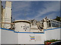
No room at this hotel
The former Bayside Hotel, along with the Chalice Bar, slowly being reduced to rubble. Sadly the hotel closed its doors some years previously, but was thought to have been occupied by homeless squatters. There were a couple of fires too, the worst in 2011 which effectively destroyed the 32-room hotel. Now it's only a matter of time.....
Image: © Neil Owen
Taken: 27 Sep 2012
0.01 miles
4
Hotels on Birnbeck Road, Weston-Super-Mare
View from Knightstone Road.
Image: © Jonathan Billinger
Taken: 15 Jul 2009
0.02 miles
5
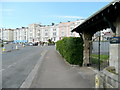
A sunny position
The row of seaview hotels along Manilla Crescent, still with gleaming paintwork and soaking up the last of the summer rays.
Image: © Neil Owen
Taken: 27 Sep 2012
0.02 miles
6
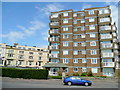
Glentworth Court, Weston-Super-Mare
A block of flats on Knightstone Road, overlooking the Marine Lake.
Image: © Jonathan Billinger
Taken: 15 Jul 2009
0.03 miles
7
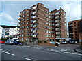
Madeira Court and Glentworth Court, Weston-super-Mare
Multi-storey flats on the seafront. Madeira Court is on the right.
Image: © Jaggery
Taken: 27 Sep 2012
0.03 miles
8
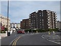
Block of flats (Glentworth Court) overlooking Marine Lake
Image: © David Smith
Taken: 20 Apr 2012
0.04 miles
9

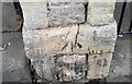
Ordnance Survey Cut Mark
This OS cut mark can be found on the wall of No3 Manilla Crescent . It marks a point 10.421m above mean sea level.
Image: © Adrian Dust
Taken: 30 Jul 2018
0.04 miles
10
Ordnance Survey Cut Mark
This damaged OS cut mark can be found on the gatepost of No4 Highbury Road. It marks a point 34.503m above mean sea level.
Image: © Adrian Dust
Taken: 30 Jul 2018
0.04 miles