IMAGES TAKEN NEAR TO
Lower Norton Lane, WESTON-SUPER-MARE, BS22 9YR
Introduction
This page details the photographs taken nearby to Lower Norton Lane, BS22 9YR by members of the Geograph project.
The Geograph project started in 2005 with the aim of publishing, organising and preserving representative images for every square kilometre of Great Britain, Ireland and the Isle of Man.

There are currently over 7.5m images from over14,400 individuals and you can help contribute to the project by visiting https://www.geograph.org.uk
Image Map (Loading...)


Getting Data...Please wait
Leaflet Map data © OpenStreetMap
Images are licensed for reuse under creativecommons.org/licenses/by-sa/2.0
Notes
- Clicking on the map will re-center to the selected point.
- The higher the marker number, the further away the image location is from the centre of the postcode.
Image Listing (47 Images Found)
Images are licensed for reuse under creativecommons.org/licenses/by-sa/2.0
Image
Details
Distance
1
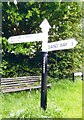
Direction Sign - Signpost by Norton Lane, Norton
Pyramid finial - 2 arms; Somerset SCC pyramid by the UC road, in parish of Kewstoke (North Somerset District), in Norton, on the southeast side of the junction of Lower Norton Lane and Norton Lane.
Surveyed
Milestone Society National ID: SO_ST3463B
Image: © J Dowding
Taken: 1 May 2013
0.04 miles
2
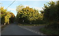
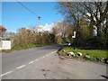
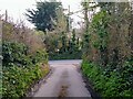
Junction at Norton
Norton Lane turns right off the busy Lower Norton Lane.
Image: © Derek Harper
Taken: 18 Oct 2016
0.04 miles
3
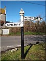
Fingerpost on the corner of Norton Lane and Lower Norton Lane
Fingerpost on the corner of Norton Lane and Lower Norton Lane. It shows left is Sand Bay in a mile, and right is Weston-super-Mare for 4 Miles and Bristol for 19¼ miles. The building in the photograph is Norton Farmhouse.
Image: © s
Taken: 27 Mar 2023
0.04 miles
4
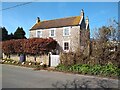
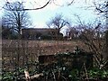
Norton Farmhouse
Norton Farmhouse was built in the late 19th century or early 20th century. It didn't appear on maps until the 1894-1903 OS 25" 2nd Edition Somerset.
Image: © s
Taken: 27 Mar 2023
0.04 miles
5
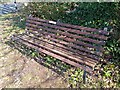
Bench on the corner of Lower Norton Lane and Norton Lane
This bench on the corner of Lower Norton Lane and Norton Lane in the heart of Norton was donated by the Birmingham Hospital Saturday Fund Charitable Trust for the Kewstoke Golden Jubilee on 2nd July 1983.
Image: © s
Taken: 27 Mar 2023
0.05 miles
9
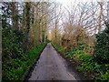
Foss Lane looking South
Foss Lane looking South towards the junction of Lower Norton Lane
Image: © s
Taken: 27 Mar 2023
0.05 miles
10
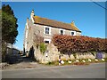
Norton Farmhouse
Norton Farmhouse was built in the late 19th century or early 20th century. It didn't appear on maps until the 1894-1903 OS 25" 2nd Edition Somerset.
Image: © s
Taken: 27 Mar 2023
0.05 miles